Watch/Warning Summary
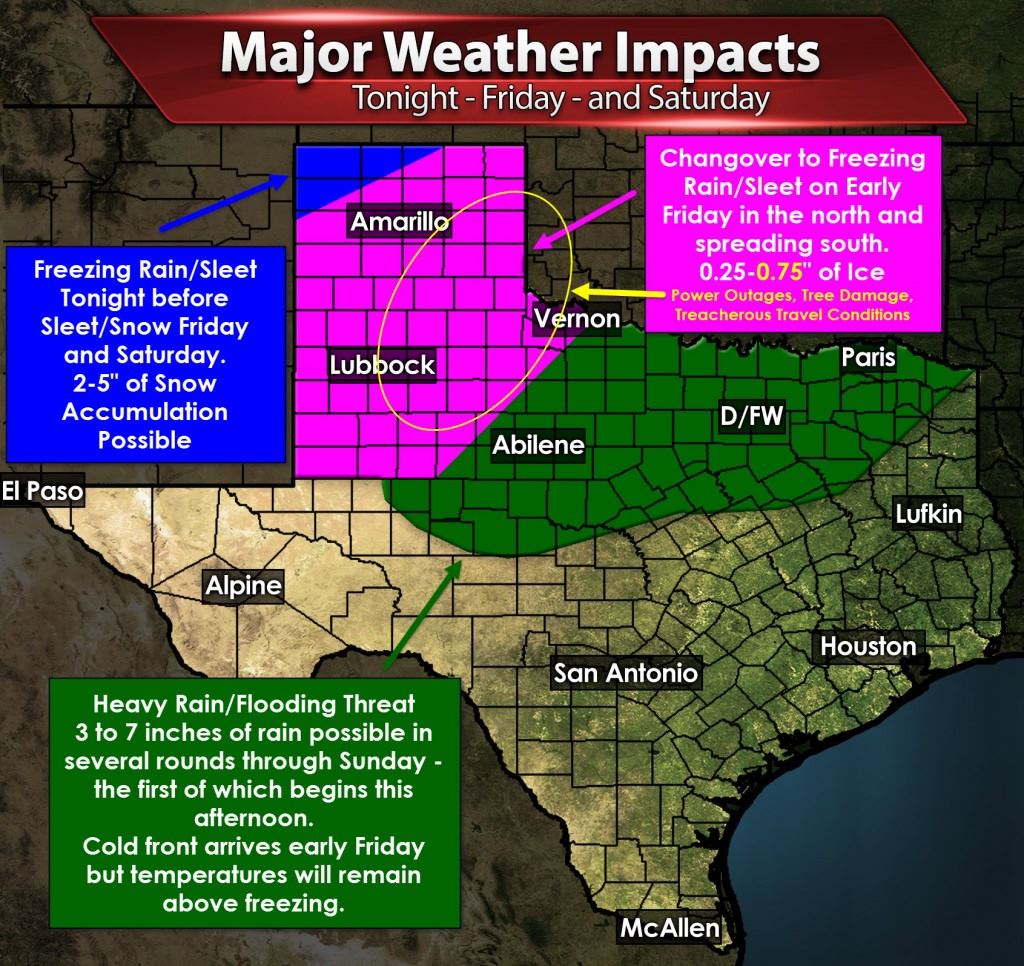
Ice Storm Warning for all of the Texas Panhandle beginning late tonight and lasting through Saturday. A major winter storm will bring significant accumulations of ice to much of the Texas Panhandle. The northwest Texas Panhandle may end up with more sleet/snow. Substantial accumulations are possible which will make road conditions treacherous. Some ice accumulations over 0.50″ are possible which would result in an enhanced risk of power outages, tree damage, and some infrastructure damage due to strong north winds.
Updated at 5:48 AM: A Ice Storm Warning is in place for the South Plains and Rolling Plains in West Texas. Like the Panhandle a major ice storm is possible across parts of the region with ice accumulations of 0.25″ to 0.50″+ possible. Travel conditions will be extremely hazardous. Power outages, tree damage, and some infrastructure damage will be possible where ice accumulations exceed half an inch.
Less significant accumulations of ice are possible across parts of the Big Country into Northwest Texas on Friday and Friday Night. The risk for significant ice is lower for now but any ice that develops could make bridges and overpasses slick and hazardous. Check back for forecast updates because if the colder air moves more quickly than there is the potential for a more substantial winter weather event.
A Flash Flood Watch is in effect for much of North Texas, Northeast Texas, and Texoma. Temperatures will be too warm for winter precipitation but moisture content in the atmosphere will be much greater. Several rounds of precipitation are expected with the first heavy batch arriving later this afternoon. A second round will occur Friday morning and a third Friday Night into Saturday Morning. 3 to 7 inches of rain will be possible with localized amounts up to 10 inches. Not all of that will fall at once since this event will be spread out over three days. Nevertheless soil conditions remain saturated from past events and the threat for flash flooding will be high. Do not drive into flood waters and don’t let your kids play in them either. Temperatures will be much colder on Friday and Saturday making for miserable conditions.
Discussion
Let me start out by wishing you all a Happy Thanksgiving. Even though we’re going to be dealing with a variety of major weather issues over the coming days I’m thankful that we’ve ended our multi-year drought. I’m thankful that we didn’t have any loss of life with last week’s tornado outbreak in the Panhandle. Finally I’m thankful that so many have come to trust our weather blog as their daily source for weather information. Never did I imagine that we would have the audience we do today. Paige and I will be making a bit of a road trip later on to have Thanksgiving dinner with my family.
There will be no issues with winter weather until late tonight across the Panhandle. The winter weather threat will shift south as temperatures fall below freezing on Friday across the South Plains, Rolling Plains, and perhaps some of Northwest Texas. As pointed out in the warning summary there is the potential for a major ice storm in parts of the Panhandle, South Plains, and Northwest Texas. The threat also looks to include the western half of Oklahoma – perhaps as far east as Oklahoma City. Road conditions will be hazardous and travel is strongly discouraged on Friday and Saturday in the Texas Panhandle, West Texas, and in Western Oklahoma. We’ll have to closely watch the progress of the cold front. If the front is a little faster or a little stronger than expected we may have to pull the freezing line further southeast. We don’t expect any winter weather in North Texas or the D/FW Metroplex (including Interstate 35) – we’ve had several questions about that.
Ahead of the cold front temperatures are quite warm for late November. This morning temperatures are in the 60s across much of Texas except the northern Panhandle where the cold front is beginning to arrive. These warm temperatures will continue with gusty south winds today and tonight. As the cold front arrives at a given location you can expect winds to become gusty out of the north along with a quick 20 degree temperature drop. That will occur later today across the Texas Panhandle, tonight across West Texas, Northwest Texas, and locations north of Interstate 20, and into Friday for folks in the Hill Country and Central Texas. The front has been moving a little more quickly so these arrival times are subject to change.
The first round of heavy precipitation is expected to develop this afternoon across the Big Country into Northwest Texas. This area of heavier rain and storms will move east into North Texas by mid-afternoon and into Northeast Texas this evening. Short-term weather models have indicated a little more instablity this afternoon in a small section of North Texas generally from D/FW north to the Red River. We’ll have to keep an eye on a low severe weather risk this afternoon in that small region. In all likelihood the severe weather threat won’t materialize – but if it does we may see one or two storms become severe with localized damaging wind gusts and perhaps a brief tornado. Any severe weather threat would diminish after sunset. A Flash Flood Watch begins at 6 PM for North Texas and continues into Saturday.
With the blog already longer than I wanted we’ll end it here. We’ll likely be on the quiet side through the afternoon hours as we spend time with our families. We’ll post updates as needed if we see any major forecast changes. We’ll have another detailed update tonight or sooner if necessary. Have a great Thanksgiving!


0 Comments