
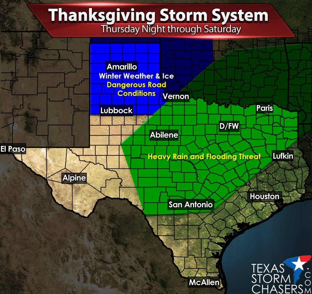
Forecast Highlights
- Winter Storm ramps up Thursday Night across the Panhandle as temperatures fall below freezing. Rain will change to freezing rain/sleet across parts of the South Plains and far Northwest Texas on Friday. Hazardous Travel Conditions are expected Friday and Saturday across the Texas Panhandle, portions of the South Plains, and Western Oklahoma.
- Several rounds of heavy rain are expected further east and south where temperatures will be cold – but remain above freezing. Flash Flooding is a threat across the Concho Valley, Big Country, Northwest Texas, North Texas, Central Texas, and Northeast Texas.
- River flooding will continue into the upcoming week as a result of upcoming heavy rain.
- A strong cold front will cause temperatures to drop 20-30 degrees by Friday and Saturday across nearly all of Texas. Gusty north winds will result in wind chills in the 10s-20s-30s (variability from north to south).
Precipitation Timing and Overall Chances
Winter Weather Accumulations

Outlook for Significant Ice Accumulations over 0.25″
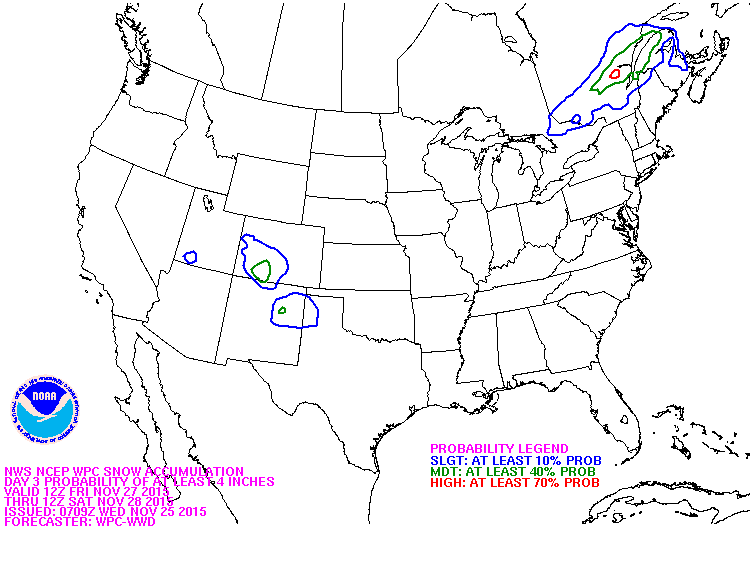
Snow outlook for over 4 inches of snow
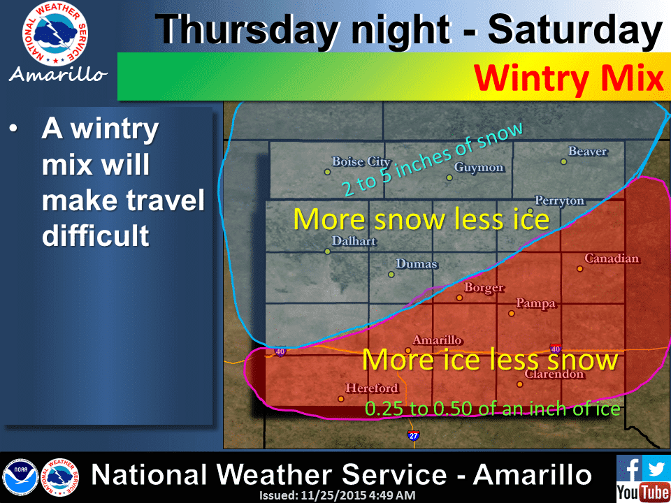
There is the potential for significant freezing rain accumulations in the southeastern Texas Panhandle into parts of the South Plains. Widespread ice accumulation totals of 0.10″ to 0.25″ appear likely at this time which will result in hazardous travel conditions Friday and Saturday. There may be a corridor of enhanced ice accumulations over a yet to be known location of 0.50″ or perhaps higher. That amount of ice accumulation is significant enough to cause damage to power infrastructure and trees. A winter mix of freezing rain initially Thursday Night may change or mix with sleet/snow by Friday/Friday Night across the central Texas Panhandle with hazardous travel conditions. The event may end as snow across the northwest Texas Panhandle where 3 to 5 inches of snow could accumulate. This event is still 48 hours out and we do anticipate forecast changes. Forecasting winter weather in Texas is difficult enough. Challenges include the timing of a cold front and how quickly temperatures will fall below freezing. A layer of warm air about 4,000 feet ASL will determine the precipitation type (Freezing rain, sleet, snow etc). A thicker warm layer would result in all freezing rain. A thinner warm layer would allow for sleet and eventually snow.) Thus the accumulation forecast depends greatly on the type of precipitation falling. Regardless hazardous travel conditions are expected across the Texas Panhandle, parts of the South Plains, perhaps Far Northwest Texas, and western Oklahoma on Friday and Saturday. This includes Interstate 40, Interstate 27, and US Highway 287 to name a few of the major roads.
Heavy Rain/Flood Potential
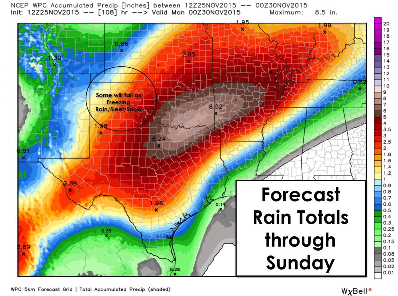
There will be multiple rounds of rain over the next few days across the eastern two-thirds of Texas. Light rain may develop later today across South Texas. Mist or light rain is possible tonight as warm air advection causes low clouds and overall dreary conditions to spread north. The weather will actually be warm for late November as high dewpoint values spread inland. Combined with moisture from now Hurricane Sandra in the eastern Pacific the stage will be set for a classic El Nino precipitation event. One round of heavy rain will occur tomorrow morning across the Texas Panhandle. This first round will be all liquid rain for the Panhandle as temperatures will still be above freezing. By Thursday Afternoon moderate to locally heavy rain will be possible across South-Central Texas into East Texas. Heavy rain will then develop late Thursday/early Friday across the Big Country, Northwest Texas, and North Texas. Rain will remain possible during the afternoon hours on Friday but it may be lighter across Texas – a lull between heavier rounds. A third round of widespread heavy rain will spread across Southwest Texas, the Big Country, the Concho Valley, North Texas, and Northeast Texas on Saturday. This is the timeframe when the flooding potential will be highest. Winter weather will be occuring where temperatures are below freezing in the Texas Panhandle and portions of the South Plains. Flash Flood Watches will be issued later today or on Thursday for many of the locations I named here. Rain chances will end from west to east Saturday Night into Sunday.
Summary
Today is going to be windy and warm across Texas. A few light showers are possible. Compared to Thursday, Friday, and Saturday travel conditions today will be fairly good. Sunday won’t be as bad either as we have precipitation move out. Unlike today there could be issues on Sunday from flooded roadways in the eastern two-thirds of Texas. Slick spots are possible across the Panhandle from their winter storm. Sunday and Monday will be dry before another system moves into Texas starting on Tuesday through Thursday. We could have more issues but I prefer to only focus on one storm at a time.


0 Comments