
A tornado watch is now in effect until 1 AM for portions of Texoma, North Texas, and Northeast Texas. This includes Bowie, Mineral Wells, Granbury, D/FW, Sherman, Canton, Tyler, Longview, Texarkana, and Paris. Not all locations in the watch area will be impacted by severe weather this evening. We have our first storms of the day going up in the northwestern sections of the watch zone. The strongest storms over the coming hours may produce very large hail up to the size of baseballs, localized damaging wind gusts to around 70 MPH, and even an isolated tornado. Keep in mind all thunderstorms produce deadly lightning. We’re all out chasing and thus updates will be infrequent. Please use the links at the top of the site for useful information.
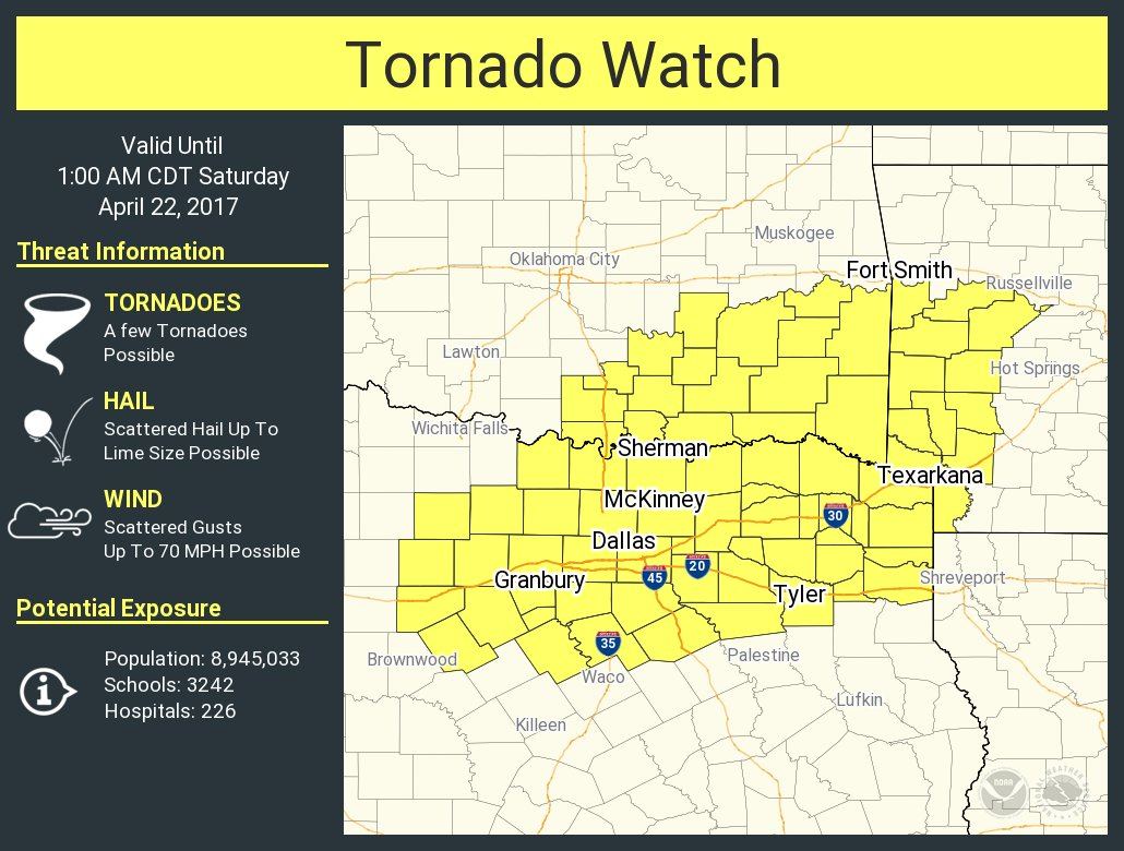
Tornado Watch Number 155
NWS Storm Prediction Center Norman OK
440 PM CDT Fri Apr 21 2017
The NWS Storm Prediction Center has issued a
* Tornado Watch for portions of
western Arkansas
southeast Oklahoma
north centrtal and northeast Texas
* Effective this Friday afternoon and Saturday morning from 440
PM until 100 AM CDT.
* Primary threats include…
A few tornadoes possible
Scattered large hail and isolated very large hail events to 2
inches in diameter possible
Scattered damaging wind gusts to 70 mph possible
SUMMARY…A few supercells are expected to develop in vicinity of a
cold front and convectively reinforced boundary, and some storms may
evolve into line segments. Large hail, damaging wind and a few
tornadoes will be possible with this activity this evening.
The tornado watch area is approximately along and 110 statute miles
east and west of a line from 20 miles east northeast of Poteau OK to
45 miles south southeast of Fort Worth TX. For a complete depiction
of the watch see the associated watch outline update (WOUS64 KWNS
WOU5).
PRECAUTIONARY/PREPAREDNESS ACTIONS…
REMEMBER…A Tornado Watch means conditions are favorable for
tornadoes and severe thunderstorms in and close to the watch
area. Persons in these areas should be on the lookout for
threatening weather conditions and listen for later statements
and possible warnings.


0 Comments