
A bit of a complicated forecast for tomorrow with regards to the severe weather threat across western north Texas and west central Texas this afternoon. First item leading to uncertainty in the forecast is the fact that the upper level low which will be generating lift across these regions tomorrow only moved on shore this morning and has had little time to be ingested by our weather balloon network. This hard data is needed in order for the various short-range models to develop a reasonably accurate forecast for the next 24 to 36 hours, so obviously we may see some forecast changes once data rolls in tonight. Second item impacting the forecast is the outlook for early morning showers and storms to develop across the panhandle and possibly south into the rolling plains region which may impact the development of storms later in the afternoon when instability is typically greatest. Another factor in play is the position of the dryline tomorrow afternoon…which could stretch from the TX/NM line west of Amarillo down to Lubbock, or a bit further east towards the Hwy 83 corridor which runs north/south from Childress to Rule. Last issue will be the position of a warm front expected to position itself somewhere along the Red River by mid afternoon tomorrow. This feature will also play a role in where storms may develop across all of north Texas tomorrow. Either way, showers and possibly a few embedded storms are likely across the panhandle by early tomorrow, and we may see an increase in storm coverage further south…mainly east of Lubbock…as the morning wears on. Once we get into the early to late afternoon hours, current data points to additional development of scattered strong to severe storms along the dryline and the warm front with this second round being the most likely to produce severe weather including hail, damaging winds and perhaps a couple of tornados. All that to say that we’ll likely see a few changes in the forecast overnight and hopefully the forecast will become more clear tomorrow.
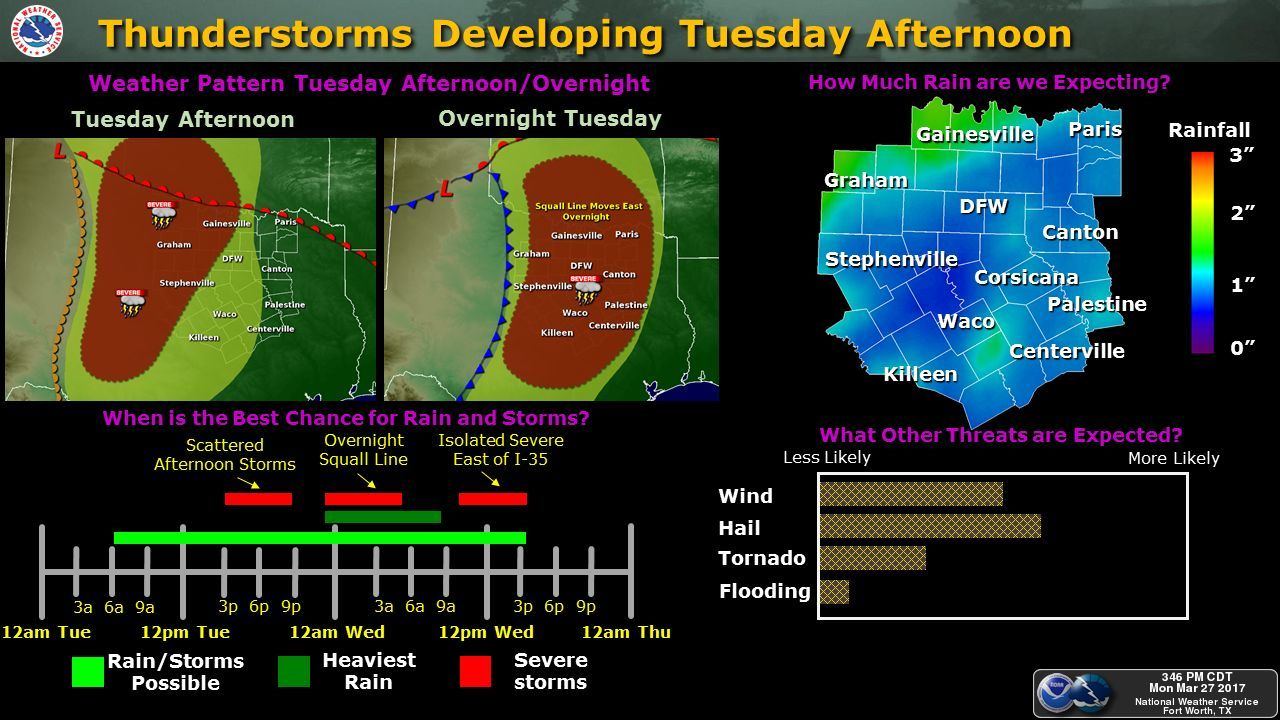
What is more clear and has been consistent in the short-range forecast models for the past several runs has been the development of a late evening/early overnight squall line of storms which will move east across north and central Texas Tuesday night into Wednesday morning. Wind, hail and heavy rain will be the main threats with the squall line overnight into early Wednesday. A few spin-up tornadoes embedded in the leading edge of the squall line are also possible, but pinpointing exactly where the greatest threats for that to set up is not possible at this time. Latest guidance has the squall line moving through the DFW area sometime between 3am and 5am Wednesday morning. Timing will depend a lot upon on the eventual position of the dryline tomorrow afternoon, the timing of best lift from the upper level low and the degree of storm development we see tomorrow afternoon across west central and western north Texas.


0 Comments