
We’ve got a lot to talk about with a very active pattern over the next ten days. It has been a couple of years since we’ve seen such a pattern setup where we have severe chances every couple of days, especially so early in the spring. However, this isn’t unprecedented or all that unusual. It just hasn’t happened in recent years. Springtime in Texas is our primary tornado season and we’ll be reminded of that as we get into April. We’ll take this one system and threat at a time before moving onto the next one. The first threat of severe thunderstorms emerges by the late afternoon hours.
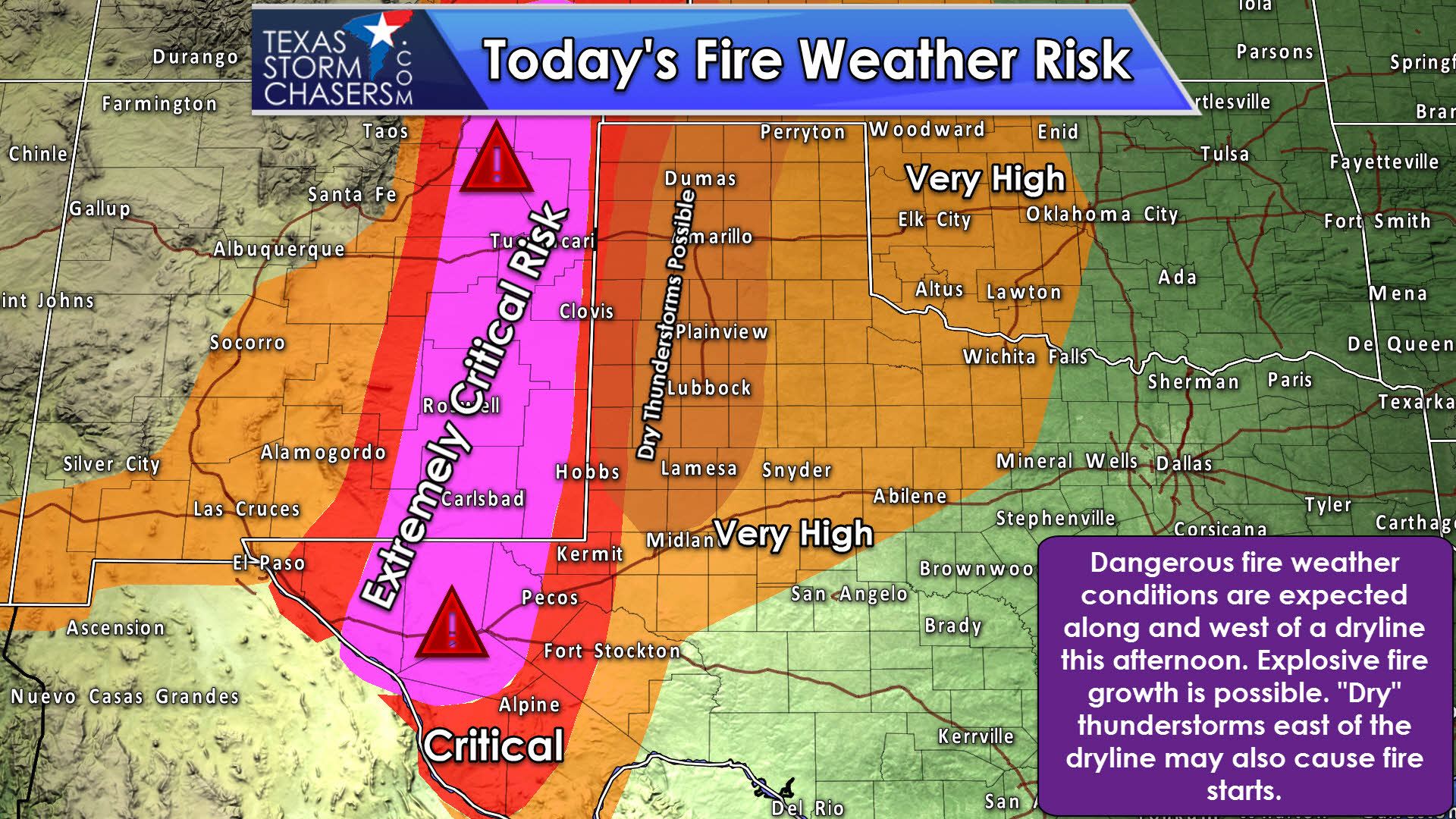
First off, we have the potential for a very active fire weather day along and west of the dryline this afternoon. An extremely critical risk designation has been put into place for the Trans-Pecos and western Permian Basin. Critical fire weather concerns exsist in the Borderland and western sections of the Texas Panhandle and West Texas. Even east of the dryline, winds gusting over 40 MPH and dry surface fuels mean any fire that develops will spread rapidly. If that wasn’t enough, thunderstorms later today may cause new ignitions. Low-precipitation supercells this afternoon may look scary, produce large hail, but little in the way of rainfall. That would be extremely problematic for new fire starts since those storms would have plenty of cloud to ground lightning – each strike could start a new fire.

A category two risk of severe weather is in place for the late afternoon and evening hours. This risk includes the central and eastern Texas Panhandle, extending south into West Texas. A category one risk extends east into Northwest Texas, the Big Country, and the Concho Valley for late tonight. You can visit our severe weather center for the latest severe weather outlooks along with an explanation of the severe weather category risk levels.
Surface dewpoints will recover into the lower to middle 50s. Typically we want to see dewpoints in the 60s for a more significant severe weather threat. The higher elevation of the Texas Panhandle can partially offset the lower moisture levels, but we’ll still see cloud bases quite high. With high cloud bases the threat for tornadoes will be low. A brief tornado can’t be ruled out near and after sunset as cloud bases lower with the loss of daytime heating. Wind shear values are very strong and that’s why, even with modest amounts of instablity and moisture, we’ll have a threat for organized thunderstorms.
The first storms should fire up between 4PM and 6PM just east of a dryline located in the central Texas Panhandle south to near Interstate 27 north of Lubbock. We may have a few hours of only a couple of discrete to semi-discrete storms. With strong wind shear in place I’d expect these discrete storms to be supercellular in nature. That means we’ll likely be dealing with a threat of large hail and the possibility of localized damaging wind gusts. High cloud bases will limit the tornado threat, but a brief tornado can’t be ruled out this afternoon or evening. The initial storms will likely weaken by early evening as they race off the northeast and move into a more stable airmass.
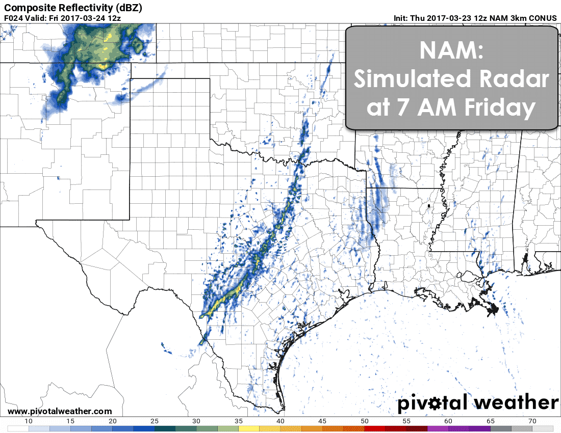
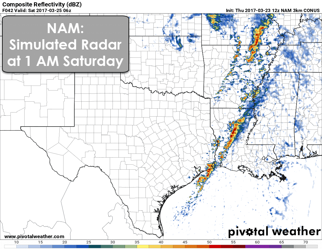
Additional showers and thunderstorms should develop by early to mid-evening as upper level lift increases. Not all of this activity will be strong to severe, but some storms may produce large hail and localized damaging wind gusts. Yesterday, we had an idea that we would see a line of storms form and progress east across Northwest Texas, the Big Country, and Concho Valley. While that may still occur, the chances of an organized squall line tonight are decreasing. What we may see instead is a loosely organized area of showers and storms move east into Northwest Texas and the Big Country tonight. The risk of severe weather wouldn’t be impressive, and neither would the rainfall amounts. By sunrise Friday we should see this loosely organized area of showers and maybe a few storms located from near Sherman to Dallas to Waco to just west of Austin, San Antonio, to Del Rio.
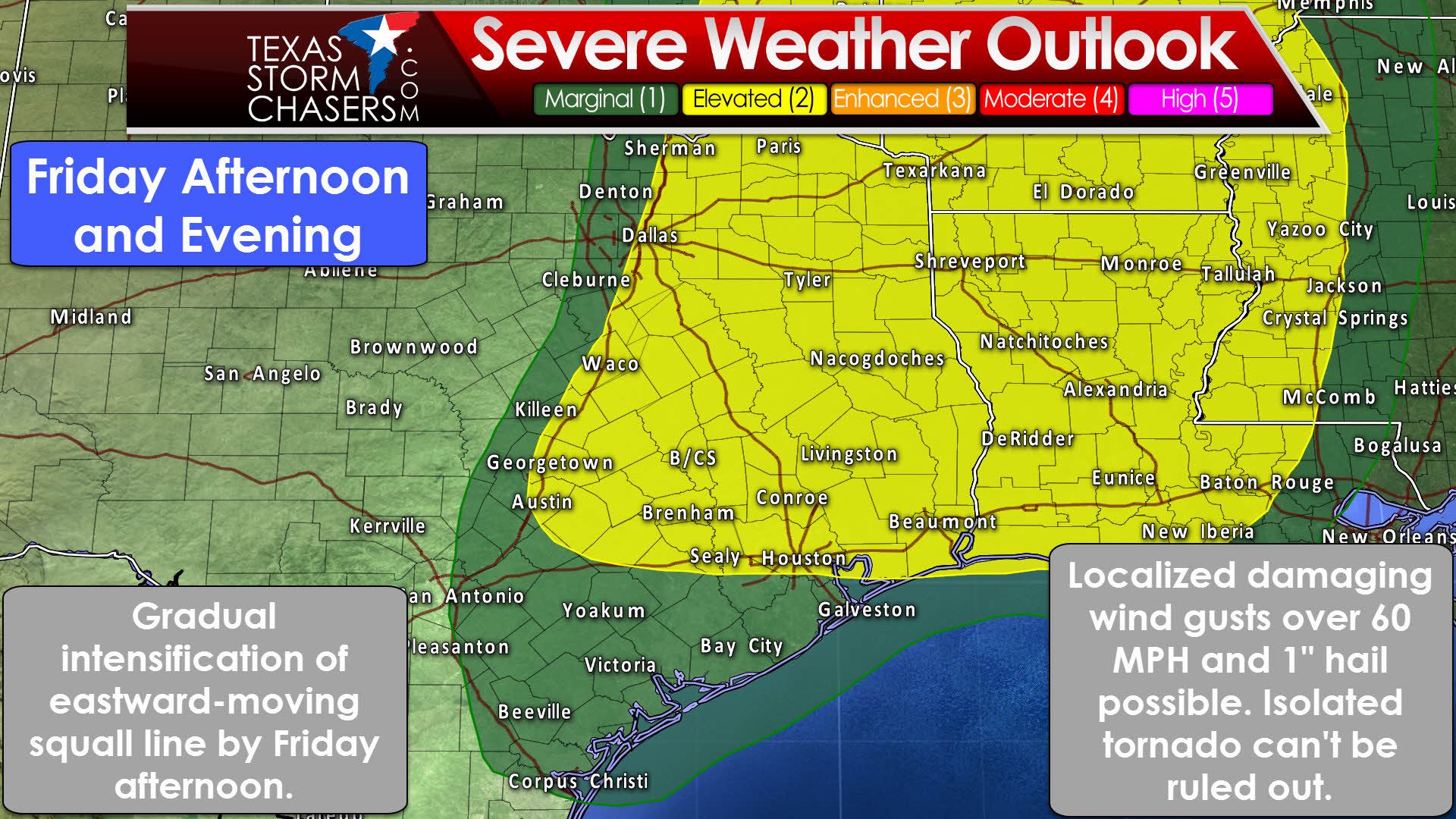
The potential for severe weather will increase by Friday afternoon in Northeast Texas, East Texas, and to a lesser extent in Southeast Texas. The loosely organized line of showers/storms will move into a more unstable enviornment. An uptick in thunderstorm intensity is expected. We should see storms continue in a linear fashion, so the primary threat with the strongest storms would be localized damaging wind gusts over 60 MPH and perhaps some hail up to the size of half-dollars. A low-end tornado threat can’t be ruled out in Northeast Texas where low-level wind shear is a bit stronger, but we would need to see discrete storms fire up ahead of the squall line for a more sustained tornado threat.

While some strong to marginally severe storms can’t be ruled out in Southeast Texas tomorrow and tomorrow evening, the strongest combination of wind shear and instability will be farther to the north. As that system starts to pull away we’ll see the storms weaken, and most of them may be gone by the mid-evening hours Friday. We’ll have to see how trends shape up over the next twenty-four hours. If our upper level storm system tracks a bit further south the storms may be able to keep going in more of Southeast Texas. Still, the higher threat for damaging winds will be in Northeast and East Texas.
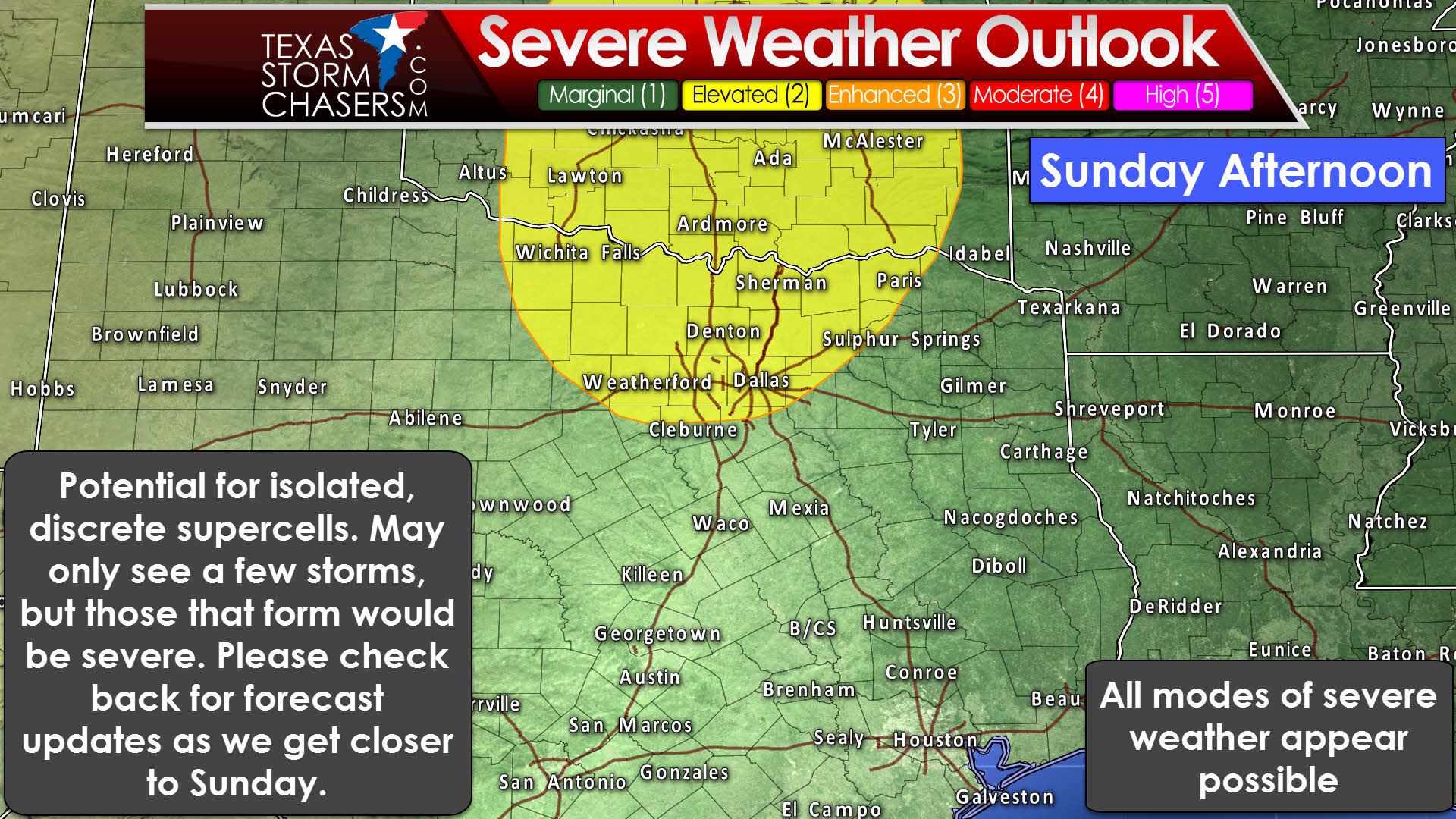
We’ll have a down day on Saturday as we end up between upper level storm systems. Those with outdoor plans should be in good shape. We don’t have to wait long for our next system as it quickly arrives on Sunday. At this time the Storm Prediction Center has highlighted Texoma and North Texas in a risk of severe weather. Do not be surprised if this outlook gets extended further south in subsequent updates. Unlike Today/Friday, the setup on Sunday will favor more isolated, discrete thunderstorms with the dryline – more typical for spring. A strong cap will be in place which will limit the number of thunderstorms, and development south of Interstate 20 is unknown at this time.
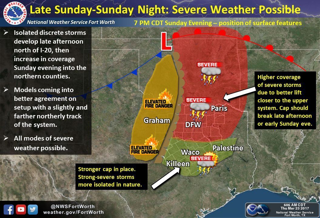
However, any storm that does manage to develop could become an intense supercell. Progged wind fields, instability values, and much higher moisture levels than this first system mean we need to watch Sunday closely. All modes of severe weather will be possible. Again, we may only see one or two storms south of the Red River (or none if the system passes further north and the cap can’t be overcome). However, any storm that forms could produce very large hail, damaging winds, and even become tornadic. We’ll see another chance of severe weather around Wednesday of next week.


0 Comments