
Strong to severe storms will be possible for areas west of the I-35 corridor from western north Texas down into southwest Texas this afternoon and evening. Initial storm development will be across western north Texas mid to late afternoon ahead of a north/south dryline. Most of the activity should develop in an area north of I-20 and east of the Hwy 6 corridor which runs north/south from Quanah down towards Knox City. These clusters of storms will move quickly off to the north/northeast towards the Red River with the main threats being quarter size hail and damaging wind gusts. The tornado threat with the afternoon storm activity is low, but is non-zero. Once we get past sunset, better forcing will arrive from an approaching upper level system with additional development possible behind the initial batch of afternoon storms. This secondary development of storms is also expected to remain just west of the DFW metroplex between Wichita Falls and Abilene. If any cells within the second round can remain isolated, those will have the best chances for tornado development before they eventually merge into an eastward moving squall line. The squall line will continue moving east overnight and early morning hours on Monday with the threat of heavy downpours and damaging winds. Widespread flooding should not be an issue, but there will be a chance for localized flash flooding especially for low lying areas and places which typically flood anytime you get a heavy downpour.
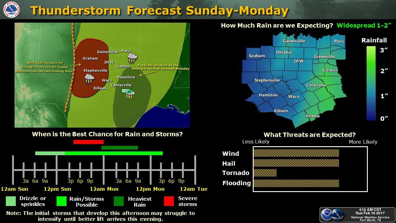
For areas south of I-20, development of isolated storms will hold off until late afternoon with cells developing along the I-35 corridor and quickly moving off to the northeast. Hail and gusty winds will be the main threat with this initial round of storms. A squall line will form west of the I-35 corridor after sunset and move east through the overnight hours into early Monday. Widespread flooding is not expected to be an issue since the system will be moving east at a fairly rapid pace, but areas that typically see flash flooding with any heavy downpour will likely have issues during the early morning hours on Monday. We’ll continue to monitor the latest development today with regard to the severe weather potential, so be sure to check back!


0 Comments