
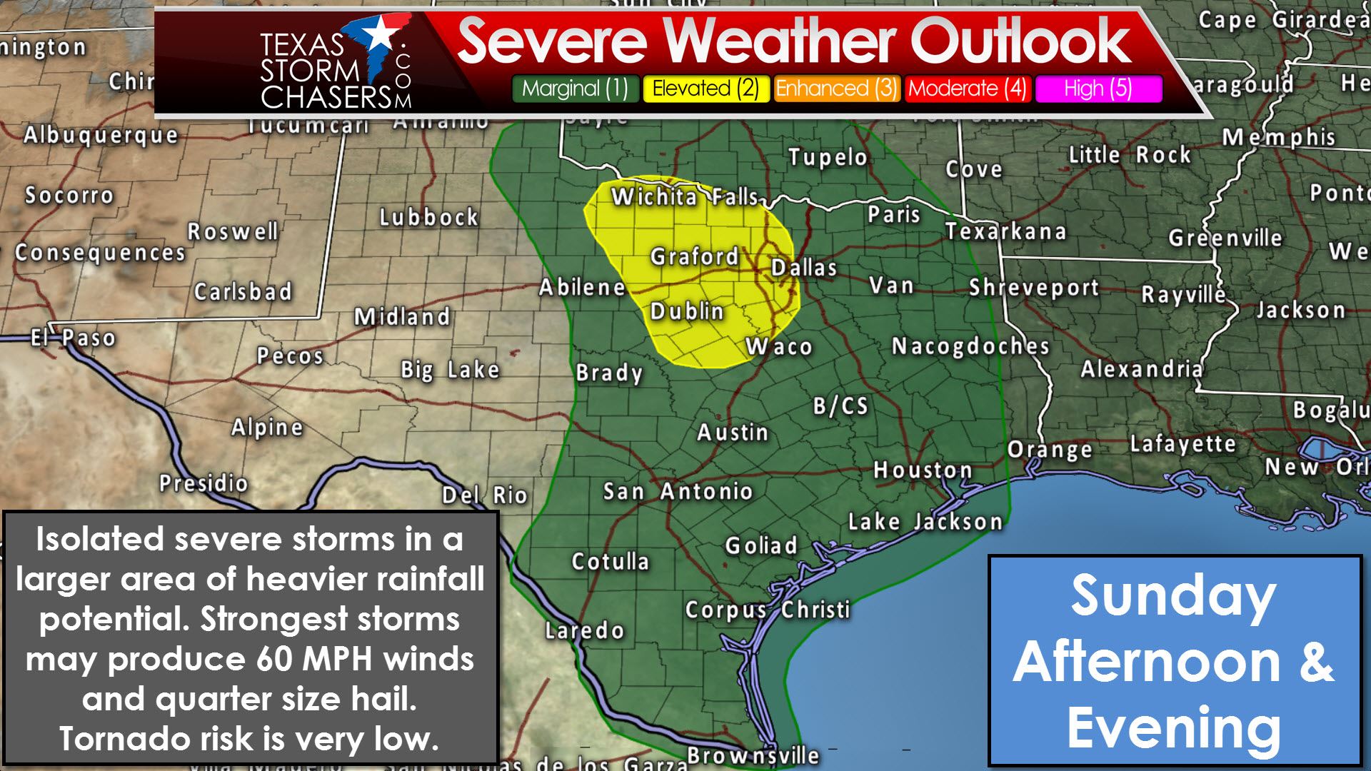
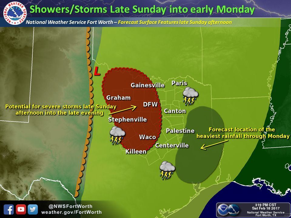
Let’s start off by showing the latest severe weather outlook for the late afternoon hours Sunday and continuing into the night-time hours. This is not anticipated to be a high-end severe weather event. However, as we’ve seen many times over the years, it only takes one misbehaving storm to cause problems – especially if that storm impacts your neighborhood. We have a category two risk of severe weather, the standard risk level from the Storm Prediction Center, for portions of North Texas and Northwest Texas. That’s the zone where we may see the relative highest chance for a couple of stronger storms. The strongest of those storms could produce localized wind gusts up to around 60 MPH and quarter size hail. A category one – marginal risk – essentially includes the eastern half of Texas. No lack of real estate, for sure! The marginal risk is where the risk for several severe storms is low, but we may see short-duration bursts of stronger wind gusts and perhaps hail up to the size of quarters. While not mentioned as a primary threat, the potential for an isolated tornado is not zero. While a few severe storms are possible with this upcoming event, the likelihood of widespread rains will be the primary impact for most folks. Localized flash flooding with heavier storms is possible.
We’ll have plenty of wind shear in the atmosphere tomorrow as a strong upper level disturbance approaches from northern Mexico. Wind shear is hardly lacking with our cool season systems, and nothing about tomorrow’s screams out of the ordinary or extremely impressive. As discussed below, the overall kinematic setup with the upcoming event suggests the primary thunderstorm mode may be linear and elevated

This complex and alien-like graphic is called a skew-t. A skew-t is a two-dimensional representation of the atmosphere. It can be for observed data, such as a weather balloon, or display what a weather model believes the atmosphere will look like at a given time. The caveat with me showing you a model generated skew-t is that the likelihood of the model being one-hundred percent right is low. Skew-t’s can show temperature, dew point, winds, and other items of interest from the surface up to around one-hundred millibars (65,000+ feet). Our specific skew-t graphic originates from this morning’s run of the Texas Tech WRF high resolution weather model and is for the D/FW Metroplex during the early evening hours Sunday. The skew-t shows plenty of directional shear and speed shear in the atmosphere of column. Those two factors would definitely support an organized thunderstorm potential, if other ingredients are in place. One big time limiting factor for surface-based storms during the day tomorrow in western North Texas, Northwest Texas, into western Central Texas is a strong inversion, known as a capping inversion. This cap, according to some of our higher resolution model guidance, will be tough to break during the day tomorrow. That leads to some concern that we may have to wait until near or after sunset Sunday for convective initiation. If we get a surface-based storm to fire up during the late afternoon hours in the regions mentioned above, we could see that storm become supercellular with a risk of all hazards, including some tornado risk. That scenario is not out of the question, but will likely depend on mesoscale factors.
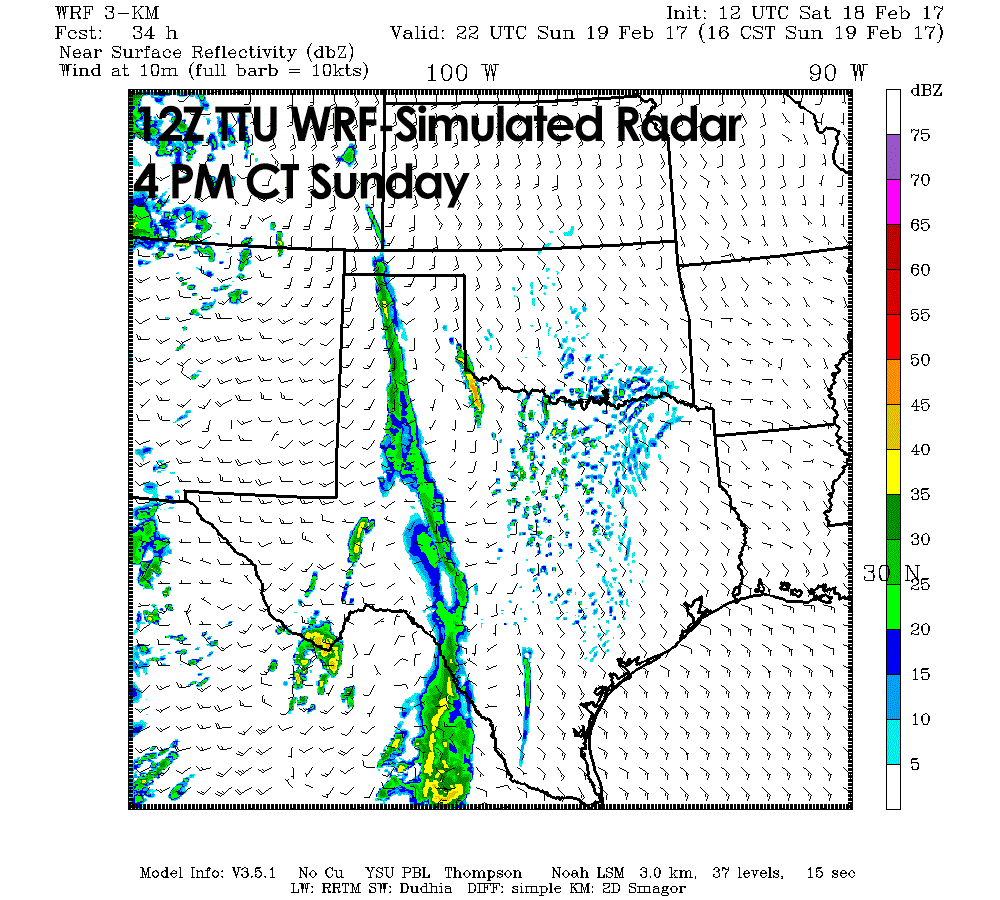
By early evening, as ascent increases with our approaching upper level storm system, we should see thunderstorms start to develop above the cap. Yes, the cap does not prevent all thunderstorms. It simply prevents surface-based thunderstorms. Storms that form above the cap can still be potent with plenty of instability and wind shear to work with. Speed shear above the cap is strong and would support organized storm modes. However, notice that the wind direction above the cap is generally unidirectional. As in, its all out of the south. Not much in the way of direction change, or directional shear. Storms in that environment would tend to be linear, or form into small line segments. There will also be some instability in the atmosphere along with copious amounts of precipitable water. With the right combination of shear and instability we could see a few storms produce localized damaging winds and some hail tomorrow evening.
The high amount of moisture means we’ll see heavier rainfall rates. Elevated storms generally do not produce tornadoes. Sometimes they can become surface-based, but again that comes down to mesoscale factors that we can’t determine outside of a few hours ahead of time. Again, unless we see a weakening trend with that cap, I’m not too concerned with our surface-based storm potential tomorrow. Could that change? This is Texas, of-course it can change. We’re going to have to watch that data closely. The best chance for a few marginally severe storms with spotty gusty winds and nickel to quarter size hail will be where the Storm Prediction Center has posted their standard category 2 risk zone in North Texas. That said, isolated severe weather will be possible across the eastern half of Texas tomorrow night. Severe weather will become less likely as we get into the late night hours Sunday and into the morning hours Monday as rain becomes widespread.
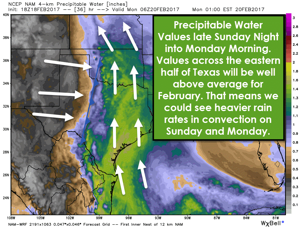
I mentioned above that precipitable water values were going to be quite high. Here’s a model output from the North American Model for tomorrow night. Precipitable water values of 1.3-1.5+ are above-average for February. That means that convection has the ability to produce heavier rainfall rates. With a unidirectional wind profile and increasing ascent we could see training thunderstorms. We’ve said that a lot over the past two years. Training storms are cells that just keep moving over the same areas. On radar it may look like the heavy rain is just sitting, or not moving much at all. With high atmospheric moisture content and potential for training storms we could see some 3 to 6 inch rainfall totals occur over very localized areas in a few hours. That’s the kind of rainfall that will cause flash flooding, recent dry weather or not.
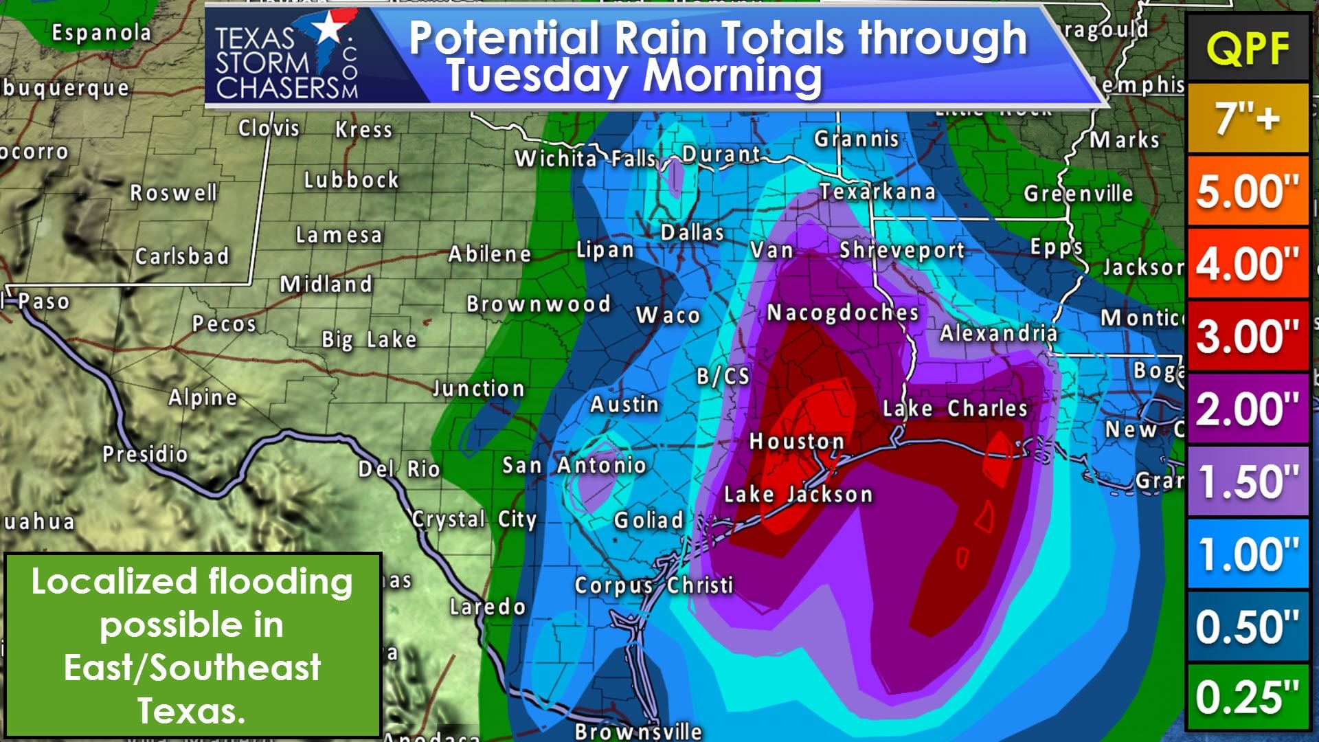
On a widespread scale we’re currently anticipated one to three inches of rain. On a large-scale we’re not expecting widespread flooding to develop. The potential for flash flooding will be highest where we see those training storms drop heavier rainfall totals, and in the urban areas where it takes less rain to cause problems. I’m looking at you Houston…
Compared to a few days ago, this system has become a bit more progressive. That means the storm system will keep moving, and we shouldn’t see it stall out over the state. Most convection will keep moving, and limit the threat of more widespread heavy rainfall and flooding threats. Localized flooding will be possible as described in detail above, but the widespread flooding threat is seemingly low at this time. Rain chances will end from west to east on Monday, obviously in western areas first. Scattered showers/storms could continue in East Texas and Southeast Texas into the evening hours Monday. This system won’t be bringing much cold weather with it and temperatures look to remain warm through the week.


0 Comments