
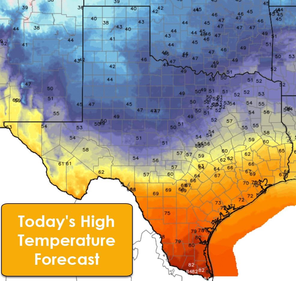
A fairly cold day is expected along and north of Interstate 20 as a slow-moving cool front brings gusty north winds and high temperatures in the 40s. Strong cold air advection, in the form of those gusty north winds, will make it difficult for temperatures to climb much today. Drizzle will remain possible through the day. Wind chill readings will be about ten degrees below the actual air temperatures. Dense fog should burn off by noon. Southeast Texas, South Texas, and the Borderland will stay on the south side of the front with high temperatures in the 60s to around 70. Deep South Texas and the Rio Grande Valley will make it into the lower 80s this afternoon. With McAllen forecast to hit 84° and Dumas at 38° this afternoon you can literally pick your season. I do enjoy playing that game! Low temperatures tonight will be near or above average for early December.
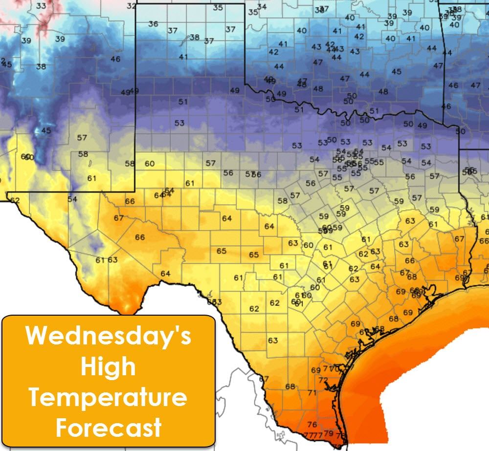
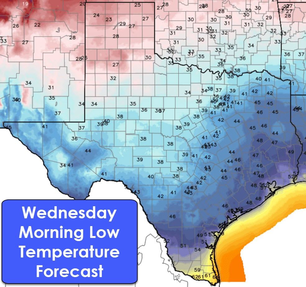
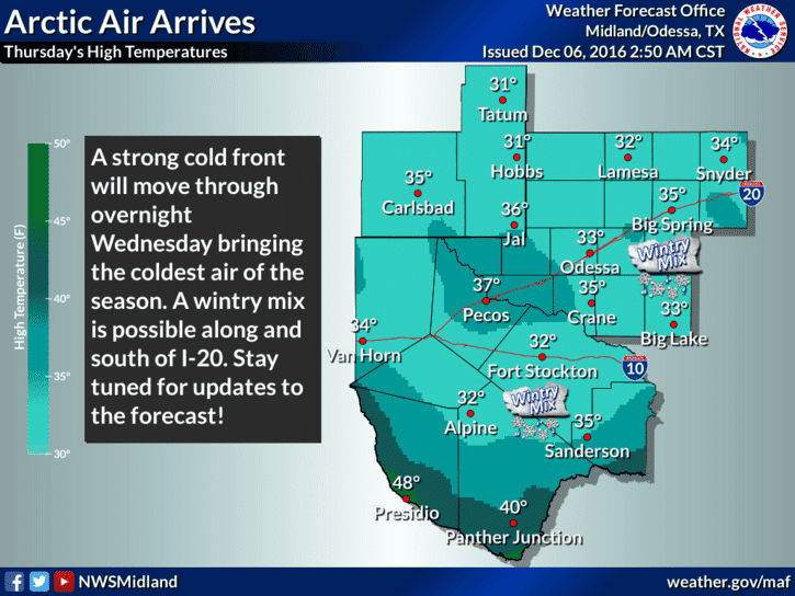
A much stronger, arctic cold front will quickly push south into Texas during the second-half of Wednesday into Thursday. High temperatures will remain in the 30s in the Texas Panhandle tomorrow, 50s to low 60s along Interstate 20, and 60s in the Big Country, Concho Valley, Hill Country, and Southeast Texas. Once again we’ll see 70s in the Middle Coast into Deep South Texas and the Rio Grande Valley. Depending on your location and the timing of the front tomorrow you may see your high temperature occur during the late morning or early afternoon. Very strong north winds behind the front will cause temperatures to rapidly drop and a brutal wind chill to develop. If the front ends up arriving during the late afternoon/early evening hours Wednesday (northern parts of Texas) then the overall diurnal temperature trend won’t be impacted too much.
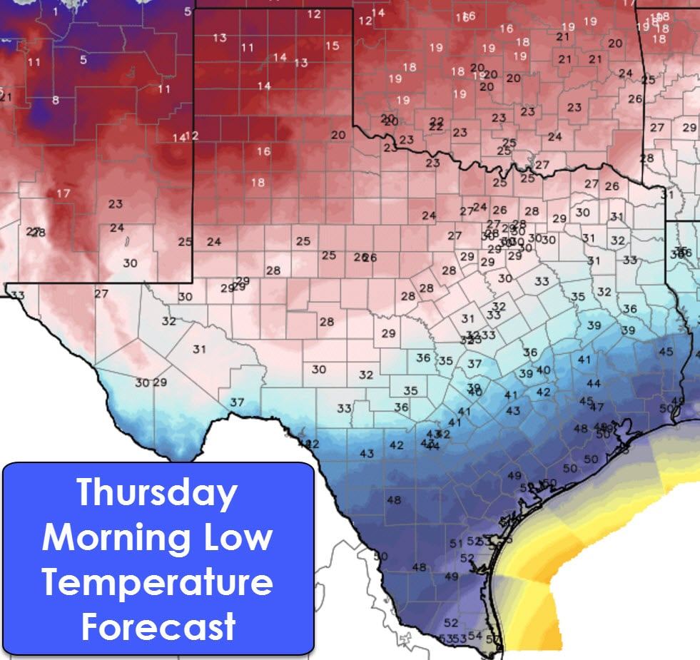
By 6 AM Thursday the cold front should be pushing south into the Concho Valley, Central Texas, the Brazos Valley and Deep East Texas. Temperatures in the Panhandle will be in the lower teens with wind chill values near zero. 20s can be expected in the Big Country, Northwest Texas, North Texas, and Northeast Texas with a strong north wind creating wind chills in the single digits to teens.
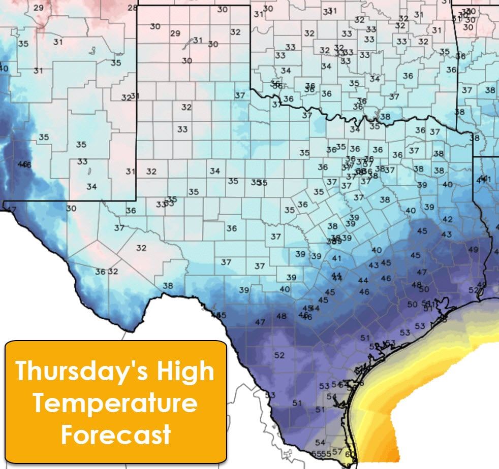
With strong north winds continuing on Thursday high temperatures will not get above the mid to upper 30s north of a line from the Hill Country through Central Texas into Northeast Texas. The Texas Panhandle and West Texas will struggle to get above freezing and may not at all on Thursday. Wind chill values will remain in the teens and twenties, although winds should start to slacken with time by Thursday afternoon. Highs will be cool, but comparatively warmer in Southeast Texas and South Texas with upper 40s to low 50s. Wind chill values in the 30s and 40s can be expected.
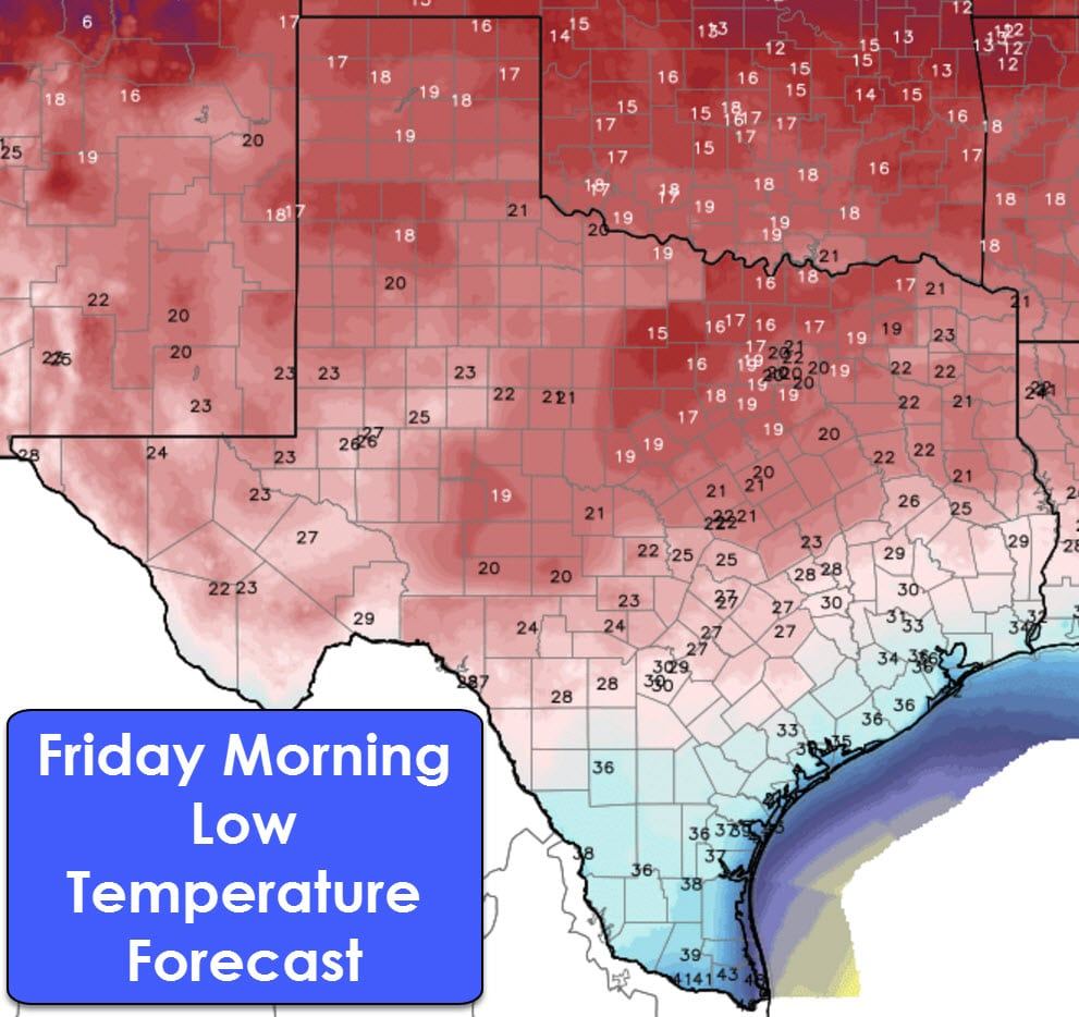
Friday morning will be the coldest of the upcoming cold snap and will feature the coldest temperatures since early 2015. Lows in the teens can be expected as far south as the Concho Valley, North Texas, and Northeast Texas. Due to these very cold temperatures we do need to advice you to protect your pipes, bring your pets indoors, do something with your plants if you don’t want them to die, and make sure your elderly neighbors stay warm. South-Central and Southeast Texas can expect a free with lower 30s. Deep South Texas will drop off into the 30s and 40s. This is a pretty nasty early-season cold snap and something we’d typically expect after a winter storm. However, we don’t expect any sort of winter storm this time around.
The good news is we’ll start to moderate during the day Friday and will see a rapid warm-up over the weekend. Highs by Saturday and Sunday should be back in the 50s and 60s.
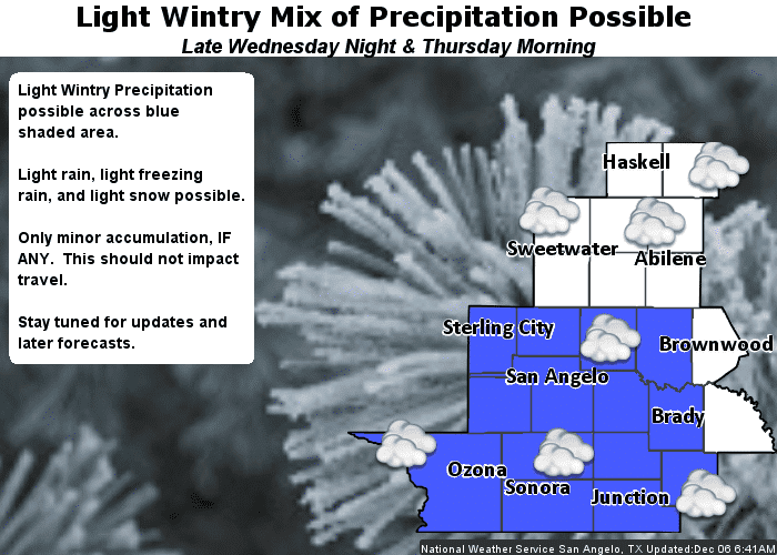
As the cold front moves south Wednesday Night and Thursday we’ll see a few chances of rain in East Texas and Southeast Texas. A couple storms are possible, but no severe weather is expected. Overall rain totals will remain below three-quarters of an inch. Rain amounts should remain low enough that flooding will not be an issue. There is a low chance of a light wintry mix in the Permian Basin and Concho Valley on Thursday. If a winter mix were to develop warm ground temperatures would likely keep surface roads in good shape. A few bridges may get slick, but the overall precipitation intensity will remain very light. If that changes we’ll let you know!


0 Comments