
Several rounds of heavy rainfall are expected across the state over the next 72 hours. An area of low pressure currently sitting and spinning over northern Mexico and southern Arizona will slowly move east over the next several days. Ahead of it, abundant tropical moisture will be flowing north from the Gulf which will work to enhance rainfall potential, especially across parts of central and south central Texas. Flooding, some severe, will most certainly be likely…especially across areas where soils are already soaked and rivers are already cresting. If you live in a flood prone area anywhere across north, central or south Texas, you’ll not want to delay in taking precautions now to secure property, livestock and activate your family’s flood safety plan.
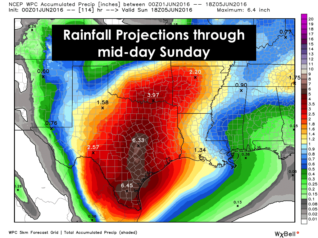
The large area of storms which impacted parts of north central Texas has moved east of the Dallas metro area into northeast Texas where the heaviest bands of rain stretched between Texarkana and Sulphur Springs. The storms which impacted the Hill Country region earlier this afternoon have moved southeast and are now impacting the coastal bend from near Port Lavaca down through Corpus Christi and west from around Falfurrias to Laredo Another round of heavy rain is also possible late tonight into early tomorrow morning across parts of north and central Texas. Whether or not that actually transpires is yet to be determined. None of the high-resolution forecast models have performed well with this system, so trying to determine the exact timing and impacts of the next round of storms is difficult at best. The atmosphere is pretty worked over behind this afternoon’s round of storms, so it’s likely that these areas will remain quiet until early tomorrow morning. Nevertheless, another piece of upper level energy is expected to emerge across the state from northern Mexico by early tomorrow morning which could lead to an additional round of heavy rain during the early morning hours. After Round 2 moves through…whenever it decides to tomorrow…we may have yet another lull in activity before the atmosphere recovers and rain chances pick up yet again. We will need to take each day’s forecast one day at a time with regard to pinpointing who will be most impacted with each round of rainfall, but know that the potential for significant flooding is in place across central and south central Texas for the next several days. We will continue to monitor and provide local updates as they arise.
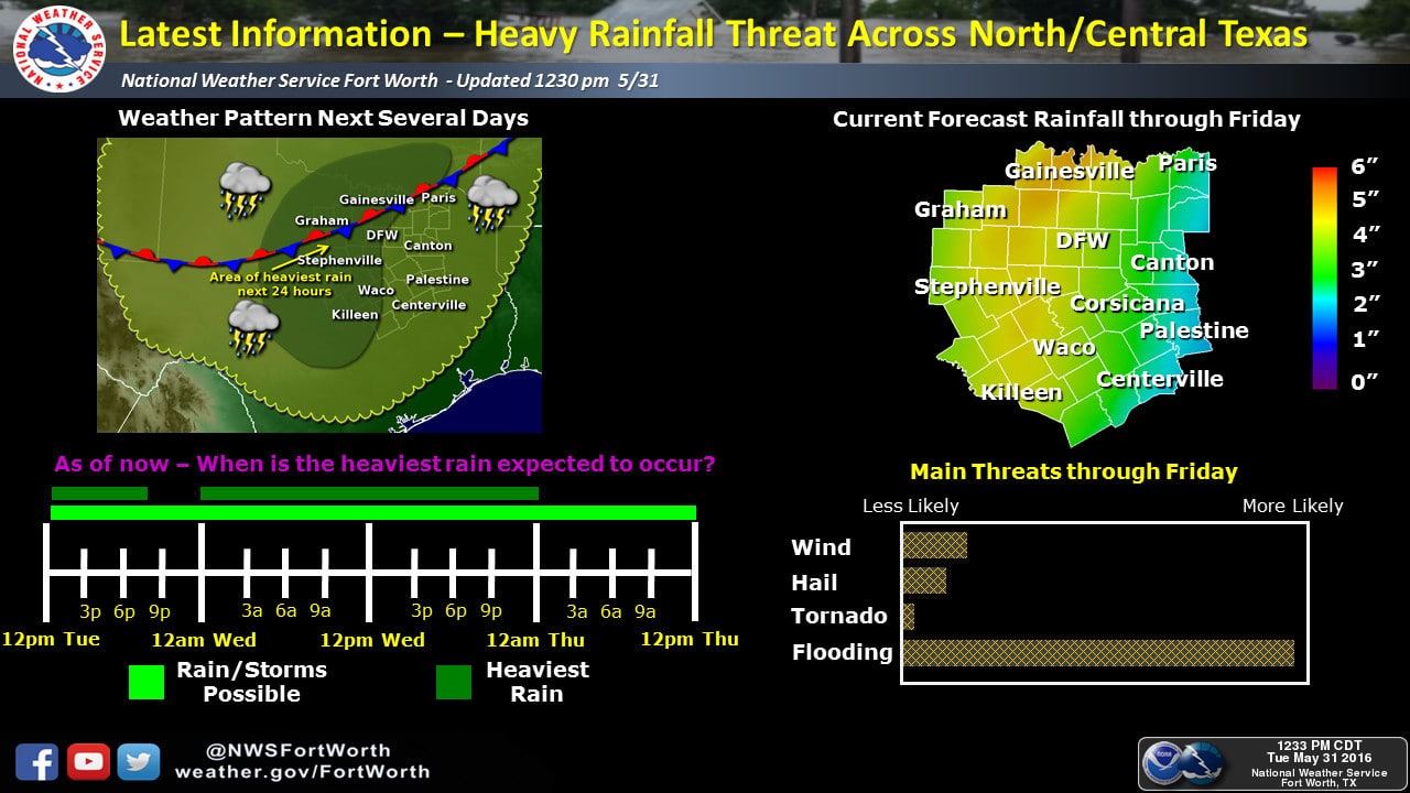
North/Central TX
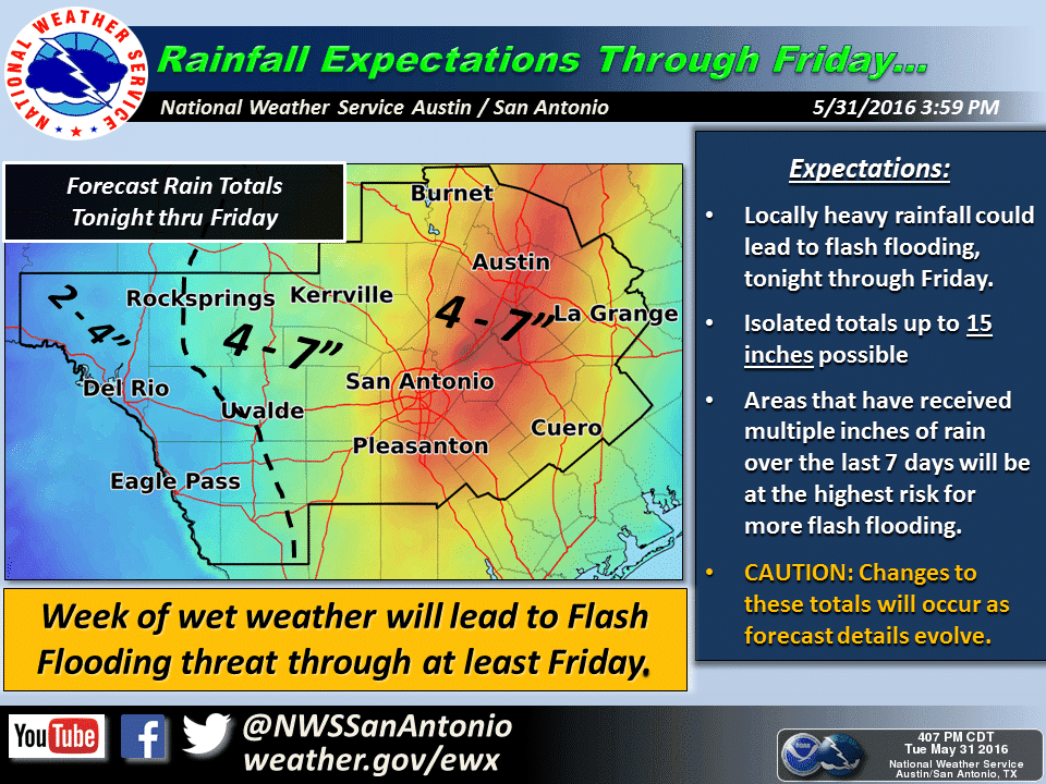
South Central Texas
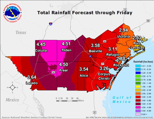
South Texas
Southeast Texas
For information on current and projected river flood conditions, visit: http://water.weather.gov/ahps2/index.php?wfo=fwd


0 Comments