
Like yesterday I’ll give full disclosure that I wrote this post at 2 AM this morning. I won’t be up at 6 AM this morning since I’ve driven 2200 miles in the past 3 days of chasing. Another chase day setting up this afternoon across the northeastern Texas Panhandle, northwest Oklahoma, and maybe southwest Kansas. Time will tell where we end up – but you’re not reading this post for my chase plans for the day. The reason I mention the early post time is because there is a complex of thunderstorms in Southwest Oklahoma again at the time of this writing. This complex of storms may move east/southeast and impact portions of the Red River Valley with a threat of localized damaging winds. Obviously we’ll know what happened with this complex somewhat by the time this post comes out around 6:30 AM. Like Monday the complex of storms could cause a few forecast adjustment for this afternoon related to the dryline and additional storm potential. Don’t be surprised if the severe weather outlook is adjusted later this morning – which we will share in an updated post after 1030AM.
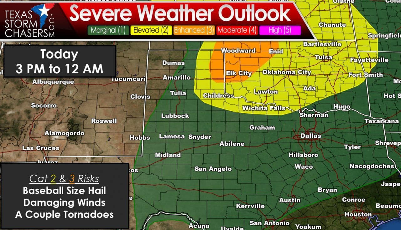
For West Texas today should actually be a nice break in thunderstorm potential. Unlike Sunday and Monday the cap is expected to be stronger with a lower chance for severe storms. I can’t rule out an isolated severe storm this afternoon but the chances are lower than what we’ve dealt with the past two days. Our focus will be on the northeast Texas Panhandle and eastrn Texas Panhandle this afternoon. The dryline will set up shop across the eastern Panhandle once again today. Storms may fire up as soon as 2 PM – but are more likely after 4 PM. Like the past two days the initial storms could become supercellular quickly with a threat of hail larger than the size of a baseball, damaging wind gusts, and the threat for a couple tornadoes. The low-level wind fields will be more impressive today – leading to a somewhat higher threat for a couple of tornadoes in the afternoon hours. We have dealt with tornadoes the past two days in the Panhandle and West Texas – but they mostly occurred after 6-7 PM as the low-level jet ramped up. This afternoon we expect the low-level jet to be in place by 4-5 PM – thus we may see a few tornadoes develop a bit earlier today. The threat for a couple tornadoes is conditional on having intense supercells – which is not a guarantee. Outflow boundaries, residual cloud cover, and any morning storms will help either make or break storm chances today. Northwest Oklahoma and Southwest Kansas are also under the gun this afternoon and evening. A complex of storms may once again develop late tonight and move into Western Oklahoma.


0 Comments