
I’ll be completely upfront when I say I wrote this at 2 AM. I say that because at the time of this writing we have a complex of thunderstorms moving into Northwest Texas near Vernon and along the Red River Valley. This complex of storms could play a role in storm development later today in the form of outflow boundaries. If for some reason the complex of storms maintains itself as it pushes into Northwest Texas and North Texas this morning some of the storms could contain gusty winds. Yet another busy afternoon and evening is expected east of the dryline as supercells develop by mid-afternoon and continue into the early evening hours. Those supercells may congeal into a cluster/line, like this past night, and push east with a threat of wind damage.
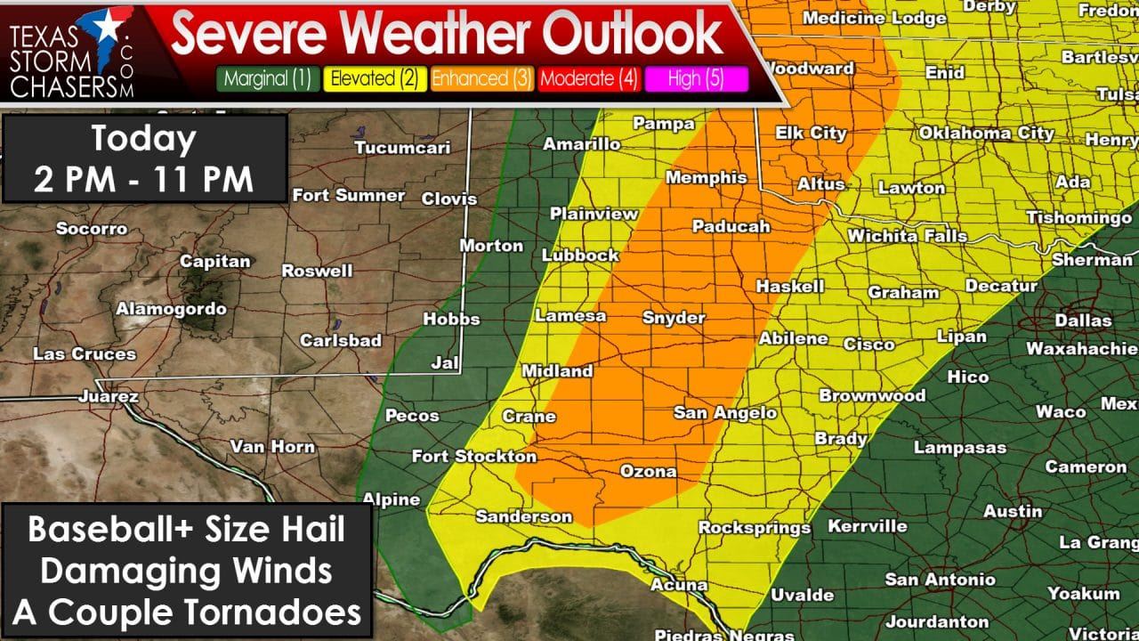
The Storm Prediction Center has issued an enhanced risk of severe weather – a category 3 out of 5 risk – for the eastern Texas Panhandle, West-Central Texas, western sections of the Big Country and western Concho Valley. A category 2 severe weather risk includes the central Texas Panhandle, Rolling Plains, and western North Texas. Like Sunday this afternoon primarily will be a discrete-thunderstorm mode event initially during the first few hours of the event today. The dryline should set up about 50-75 miles east of where it was Sunday – but I caution you that many storms on Sunday formed well east of the dryline. The first storms today may form after 2 PM – and we will likely have a couple severe storms underway by 4 PM in the eastern Texas Panhandle south into West-Central Texas into western sections of the Concho Valley. The atmosphere should be very unstable and wind shear values will support organized supercell thunderstorms. With a supercellular mode and very high instablity values the threat of very large hail will exist. Some hail stones may approach the size of a baseball or even a softball. A couple tornadoes will also be possible – especially with any sustained intense supercell that interacts with an outflow boundary left over from Sunday’s storms. Damaging wind gusts and localized flooding are also threats.
The complex of thunderstorms ongoing earlier this morning in Northwest Texas could cause some changes to the forecast for later today. In addition outflow boundaries and other mesoscale factors may help cause some minor changes. Please check back after 10 AM for an updated forecast that will contain any changes compared to what we have early this morning.


0 Comments