
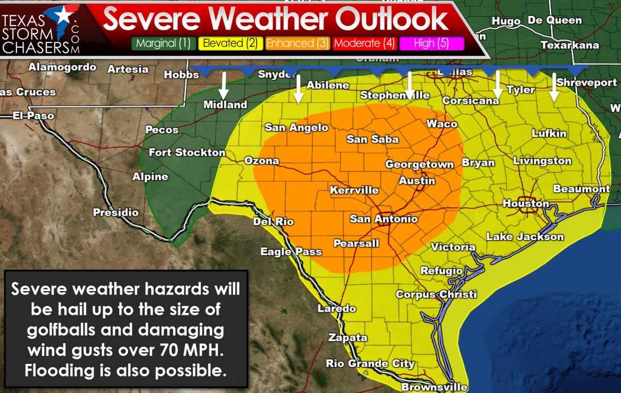
Tuesday is expected to be a busy thunderstorm day. The Storm Prediction Center has now expanded the category 3 enhanced severe weather risk to include the Concho Valley, Hill Country, South-Central Texas, and Central Texas. San Angelo, San Antonio, Austin, Waco, and Brownwood are a few towns included in the enhanced risk zone. A category 2 severe weather risk includes Abilene, D/FW, Tyler, and Longview. From that point it includes everyone south to the Mexico border. The Rio Grande Valley, Deep South Texas, the Coastal Plains, Southeast Texas, East Texas, and the Brazos Valley are all included in the standard category 2 severe weather risk. For comparison – the category 2 and category 3 severe weather risks include 162,000 square miles of Texas and over 20,000,000 Texans. Now before all 20 million of you freak out and think you’re going to get hit by severe weather tomorrow – relax – you won’t. Those in the category 2 risk zone have about a 1 in 6 chance of a severe storm occuring within 25 miles of your location on Tuesday. Those in the enhanced risk (category 3) have a nearly 1 in 3 chance of having a severe storm occur within 25 miles of your location. In percentages – those in the category 2 risk have a 15% chance of a severe storm, defined as quarter size hail or larger, 58 MPH winds or higher, or a tornado occurring within 25 miles of your location. The category 3 enhanced risk zone has a 30% chance of a severe storm occuring within 25 miles of a given location.
The threat of tornadoes will be very low tomorrow. A southward advancing cold front combined with weak low-level wind shear means I’m not really concerned about a sustained tornado threat on Tuesday. That’s not why we have an enhanced risk of severe weather. The Atmosphere is projected to be very unstable with bulk-shear values supportive of an organized convective mode. We’ll likely have a mix of multi-cellular thunderstorms with a couple supercells. A supercell doesn’t automatically become a tornado producer just because of its name. In fact a majority of supercells are non-tornadic. What we will be dealing with tomorrow are storms that could produce large hail due to the unstable enviornment. Wind shear values (as a whole) will support organized storms that may also pose a threat of damaging straight-line winds. If storms were to congeal into a cluster or squall line the threat for more widespread damaging wind gusts (60-70+ MPH) would increase – especially where we have the enhanced risk placed.
The severe weather threat will begin to ramp up after 3 PM tomorrow as the cold front lifts the cap and we see convective initiation occur. Storms may form along the front near Interstate 20 in the early afternoon and well south of the front in the warm sector as temperatures warm and capping weakens. The strongest storms tomorrow afternoon could produce large hail up to the size of golfballs. Storms in the enhanced risk zone may have a bit more instability to work with. The strongest storms in the enhanced risk zone tomorrow afternoon could produce very large hail up to the size of baseballs. I don’t expect many storms to produce that large of a hail size tomorrow – but some may. Initial storms could produce localized wind gusts up to 60 MPH. If storms congeal into a cluster of squall line the threat for more widespread damaging straight-line winds of 65 to 80 MPH would increase. That is a possibility in the enhanced risk zone tomorrow evening.


0 Comments