
We’ll be dealing with two seasons tomorrow in terms of the overall type of thunderstorms we’re expecting. I’ll start off with eastern half of Texas. Like this weekend, another round of scattered showers and thunderstorms are expected on Monday. Coverage of showers/storms will increase with daytime heating. Wind shear aloft will be weak, but with a moist environment in place, the atmosphere will be unstable. As daytime heating helps destabilize the atmosphere by the early Monday afternoon, we should see a few stronger storms start to pop up in the mass of showers. The primary threat with the stronger storms will be brief gusty winds up to 50-60 MPH over a very localized area. Known as a microburst, we typically deal with these kind of storms during the summer months. They’ve affectionately become known as popcorn storms since they tend to pop up randomly, but will usually rain themselves out within 30-45 minutes. Unlike our typical spring storms, these are not your long-lived significant severe weather producers. With a very moist environment in place, these popcorn storms will be capable of dropping very heavy rain wherever they set up. As Saturday demonstrated in Houston, you can get localized but noticeable flooding if you end up under a popcorn storm. The severe weather threat across the eastern half of Texas is a category 1 – or marginal risk – tomorrow. Severe weather will not be a widespread or significant issue – but some folks probably will be dealing with it. Now let’s move on to the more significant severe weather threat for tomorrow.
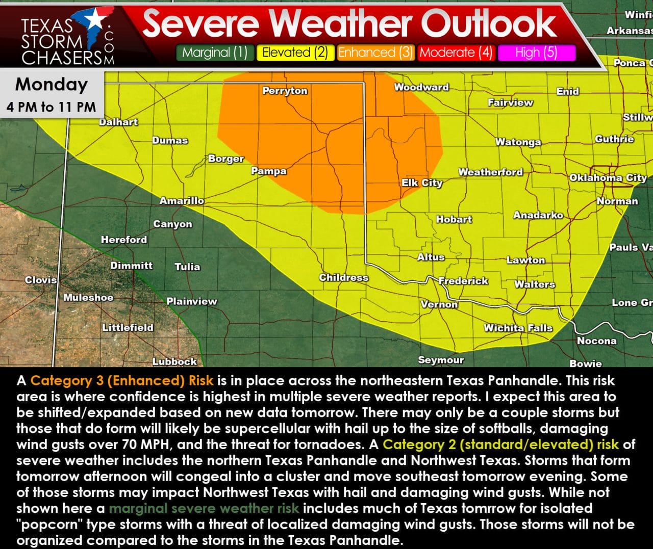
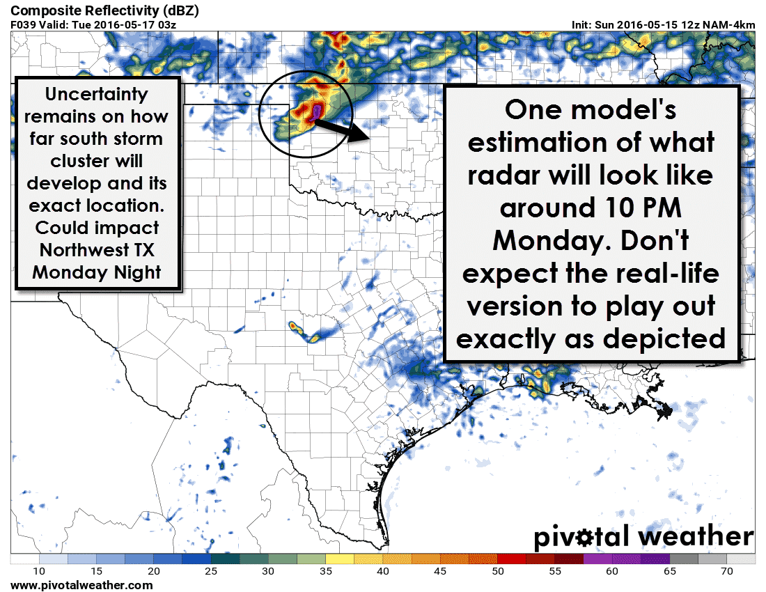
Ingredients are coming together to support a noticeable severe weather threat across the northeastern Texas Panhandle late tomorrow afternoon and early tomorrow evening; however, we have a few issues that could prevent a significant severe weather threat. An area of low pressure will develop in the western Texas Panhandle tomorrow afternoon. That low will slowly move southeast. As it moves southeast so will a cold front. If that cold front moves south too quickly, then the chance of surface-based supercells will be lessened. Storms that fire up and move north of the cold front will be elevated with a large hail threat – but the threat for tornadoes would be greatly reduced. I do expect we will see storms fire up late tomorrow afternoon and tomorrow evening along or just north of the cold front and those could be intense with large hail and significant damaging wind gusts. Another factor that will play an important role in tomorrow’s forecast is the cap to the east of the dryline and south of the cold front. Weather models are progging a strong cap – a lid on the atmosphere. If the cap is weak enough in a few areas along the dryline, we could see a few isolated storms develop which could become severe and present the threat of all modes of severe weather including a few tornadoes. If the cap is too strong, we won’t get thunderstorms to develop until the cold front arrives by the early evening hours with enough force to lift the cap. Morning cloud cover could also impact how unstable the atmosphere becomes if the clouds hang around into the afternoon hours. The reason I’m going to such lengths to explain the setup tomorrow is because the environment will be conditionally supportive of significant severe weather, but those factors such as the cap and the effects of residual morning cloud cover could influence the degree to which we see severe weather tomorrow evening.
I do believe we could see one or two thunderstorms break through the cap in the 4 PM to 7 PM timeframe across the northeastern/eastern Texas Panhandle on Monday. While the cap is forecast to be strong an upper level jet streak could be moving into the region at the times mentioned above. That jetstreak along with surface heating may be enough to break the cap and let one or two storms develop. Surface dewpoint values should be in the middle 60s in the eastern Panhandle which are high for the higher elevation out there. With the high dewpoint value and temperatures in the upper 70s to 80s the atmosphere will be very unstable. Surface-based instability values – known as CAPE (Convective Available Potential Energy) could be above 4,000 j/kg. Anything about 3,000 is considered high instability – especially in the Panhandle.
A higher area of winds in the mid-levels of the atmosphere will be moving into the Oklahoma/Texas Panhandles late tomorrow afternoon. Wind shear values in the lowest six kilometers of the atmosphere should be in the 45 to 60 knot range. We want 40+ knots of 0-6 km bulk shear for a supercellular storm mode – so we have that for tomorrow. Low-level wind shear will be lackluster in the early and mid afternoon hours. After 5 PM the low-level jet will increase as the surface low becomes more organized. With the increase in low-level wind shear conditions are looking rather volatile across the eastern Texas and Oklahoma Panhandles tomorrow. The catch is if we will have any supercells south of the cold front in an environment that is strongly capped. If we don’t see any surface-based storms develop tomorrow afternoon and early evening the potential significant severe weather will be unrealized. If we have a storm go up it will likely become severe rapidly. Very large hail up to the size of softballs would be possible along with localized wind gusts over 70 MPH. If we had a discrete, strong supercell in progress after 5-6 PM the threat for tornadoes would increase considerably. The reason we’re not forecasting a more significant severe weather/tornado event tomorrow is because there are several negative factors pointing towards a short-duration threat window. A majority of folks in the Panhandle likely won’t be dealing with severe weather tomorrow afternoon. If the one storm that possibly develops moves over your town than there could be major problems. Tomorrow is the kind of day folks in the Panhandle should be staying weather aware. If the cap holds – most of Monday will be quiet until the cold front arrives tomorrow evening with your typical springtime strong/severe storms, lots of lightning, wind, etc…but with little threat of tornadoes.
A cluster of storms will likely form along the cold front tomorrow early evening. Those storms will push east/southeast into western Oklahoma by the mid-evening with a threat of very large hail and damaging wind gusts. Storms along/north of the cold front will be elevated and pose much less of a tornado risk.
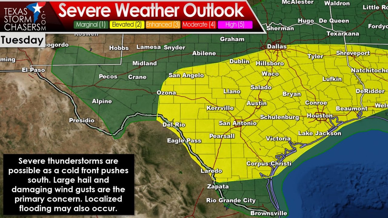
In terms of overall severe weather coverage or number of reports, Tuesday may actually be the busier of the two days. The cold front impacting the Panhandle tomorrow evening will steadily push south on Tuesday. Conditions look much less supportive of a tornado threat, but we could see another storm cluster along the cold front as it moves south. For Tuesday, the Storm Prediction Center has highlighted a category 2 severe weather risk across the Concho Valley, Hill Country, South-Central Texas, Central Texas, North Texas, East Texas, Brazos Valley, Coastal Plains, and Southeast Texas. As you can see the risk area is large and covers a lot of real estate. As the cold front pushes south through the day and night Tuesday, a line of storms should fire up in the front’s proximity. The strongest storms could produce large hail and damaging wind gusts. The setup appears favorable for an enhanced area of wind damage potential which may require an outlook upgrade as the forecast becomes more clear. A slower/faster timing of the cold front will impact which locations have to deal with the chance of stronger storms. If the front is slower, the risk will be shifted north. A faster movement may keep the risk slightly lower as storms could be ‘undercut’ and not have as much instability to work with. The environment will be extremely moist and support heavy rainfall. Some locations may pick up 3 to 6 inches of rain by Wednesday where we see multiple storms move over the same areas. Flooding become an increasing concern by Tuesday and flash flood watches may be issued for some locations.
Wednesday, Thursday, and Friday all continue to look stormy for parts of Texas. The threat for severe weather becomes more murky but periods of heavy rainfall will lead to a continued risk of flooding.


0 Comments