
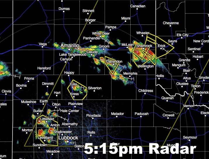
The Storm Prediction Center has issued a Severe Thunderstorm WATCH for portions of the Texas Panhandle and south rolling plains until 11pm this evening. Scattered strong to severe storms have developed across the region over the past couple of hours. The strongest cells are currently located near Shamrock, Clarendon, Claude, Tulia and just to the west of Lubbock. Frequent lightning, damaging wind gusts and hail up to 2.5 inches is possible with these storms as they continue to develop and move southeast across the region this afternoon. Don’t forget you can track these storms live using our interactive radar at texasstormchasers.com/radar
Advertisements
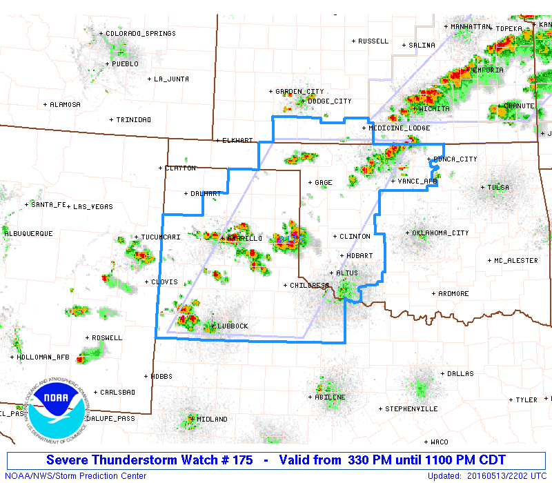
SEVERE THUNDERSTORM WATCH NUMBER 175
   NWS STORM PREDICTION CENTER NORMAN OK
   330 PM CDT FRI MAY 13 2016

   THE NWS STORM PREDICTION CENTER HAS ISSUED A

   * SEVERE THUNDERSTORM WATCH FOR PORTIONS OF
     PARTS OF SOUTHERN KANSAS
     NORTHERN AND WESTERN OKLAHOMA
     PARTS OF THE TEXAS PANHANDLE AND SOUTH PLAINS AND VICINITY

   * EFFECTIVE THIS FRIDAY AFTERNOON AND EVENING FROM 330 PM UNTIL
     1100 PM CDT.

   * PRIMARY THREATS INCLUDE...
     SCATTERED LARGE HAIL AND ISOLATED VERY LARGE HAIL EVENTS TO 2.5
       INCHES IN DIAMETER POSSIBLE
     ISOLATED DAMAGING WIND GUSTS TO 70 MPH POSSIBLE

   SUMMARY...ISOLATED THUNDERSTORMS NOW DEVELOPING SHOULD INCREASE IN
   COVERAGE AND INTENSITY OVER THE NEXT SEVERAL HOURS ACROSS THE WW
   AREA...WHERE LARGE HAIL AND LOCALLY DAMAGING WINDS ARE EXPECTED WITH
   STRONGER STORMS.

   THE SEVERE THUNDERSTORM WATCH AREA IS APPROXIMATELY ALONG AND 85
   STATUTE MILES EAST AND WEST OF A LINE FROM 30 MILES NORTHWEST OF
   ALVA OKLAHOMA TO 30 MILES EAST SOUTHEAST OF LUBBOCK TEXAS.


0 Comments