
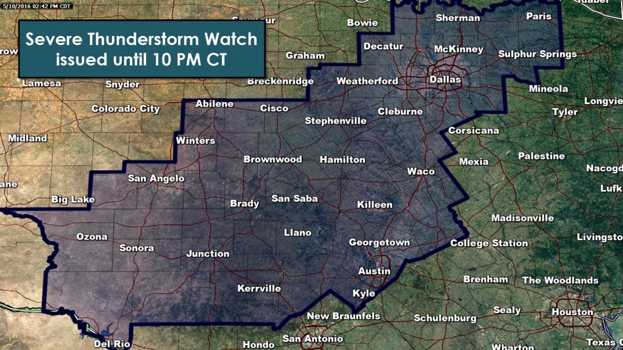
The National Weather Service in conjunction with the Storm Prediction Center have issued a severe thunderstorm watch until 10 PM covering the Concho Valley, Hill Country, Central Texas, and North Texas. Del Rio, San Angelo, Abilene, Brownwood, Kerrville, Austin, Waco, Waxahachie, Fort Worth, Dallas, Mineral Wells, Denton, McKinney, Sherman, Paris, and Sulphur Springs are all included in this watch. Thunderstorm initiation is expected within the next two hours as the cap continues to weaken. Surface temperatures have warmed into the 80s and 90s which has caused the atmosphere to become extremely unstable. Wind shear values are mediocre but suitable for a multi-cell and supercell mix. The strongest storms, supercellular in nature, will be capable of producing hail up to the size of baseballs and localized damaging wind gusts up to 70 MPH. A brief tornado is not out of the question but a very low likelihood. If storms congeal or organize into a cluster than the risk of significant straight-line winds up to 80 MPH will increase. The most likely area for a cluster of storms to organize is Central Texas this evening. Storms will initially move northeast at 15-30 MPH. As storms organize and potentially split we could see varying degrees of storm motion.
SEVERE THUNDERSTORM WATCH NUMBER 160
NWS STORM PREDICTION CENTER NORMAN OK
240 PM CDT TUE MAY 10 2016
THE NWS STORM PREDICTION CENTER HAS ISSUED A
* SEVERE THUNDERSTORM WATCH FOR PORTIONS OF
NORTHERN AND CENTRAL TEXAS
* EFFECTIVE THIS TUESDAY AFTERNOON AND EVENING FROM 240 PM UNTIL
1000 PM CDT.
* PRIMARY THREATS INCLUDE…
WIDESPREAD LARGE HAIL AND ISOLATED VERY LARGE HAIL EVENTS TO 3
INCHES IN DIAMETER LIKELY
SCATTERED DAMAGING WIND GUSTS TO 70 MPH POSSIBLE
SUMMARY…THUNDERSTORMS WILL DEVELOP SOON OVER CENTRAL AND NORTH
TX…AFFECTING THE WATCH AREA FOR MUCH OF THE AFTERNOON AND EARLY
EVENING. VERY LARGE HAIL IS POSSIBLE IN THE STRONGEST CELLS…ALONG
WITH DAMAGING OUTFLOW WINDS.
THE SEVERE THUNDERSTORM WATCH AREA IS APPROXIMATELY ALONG AND 75
STATUTE MILES EAST AND WEST OF A LINE FROM 20 MILES EAST
NORTHEAST OF SHERMAN TEXAS TO 65 MILES SOUTH SOUTHWEST OF
JUNCTION TEXAS. FOR A COMPLETE DEPICTION OF THE WATCH SEE THE
ASSOCIATED WATCH OUTLINE UPDATE (WOUS64 KWNS WOU0).
PRECAUTIONARY/PREPAREDNESS ACTIONS…
REMEMBER…A SEVERE THUNDERSTORM WATCH MEANS CONDITIONS ARE
FAVORABLE FOR SEVERE THUNDERSTORMS IN AND CLOSE TO THE WATCH
AREA. PERSONS IN THESE AREAS SHOULD BE ON THE LOOKOUT FOR
THREATENING WEATHER CONDITIONS AND LISTEN FOR LATER STATEMENTS
AND POSSIBLE WARNINGS. SEVERE THUNDERSTORMS CAN AND OCCASIONALLY
DO PRODUCE TORNADOES.


0 Comments