
There have not been many forecast adjustments since this morning’s blog post. The dryline is currently located in western North Texas and will slowly move east early this afternoon. By 3 PM it should be in the vicinity of Interstate 35/Interstate 35W in North Texas. For those unfamiliar with the area that places the dryline over the D/FW Metroplex. Since no major forecast updates are required with this update I’ll use a bullet system type post to get the information out more quickly.
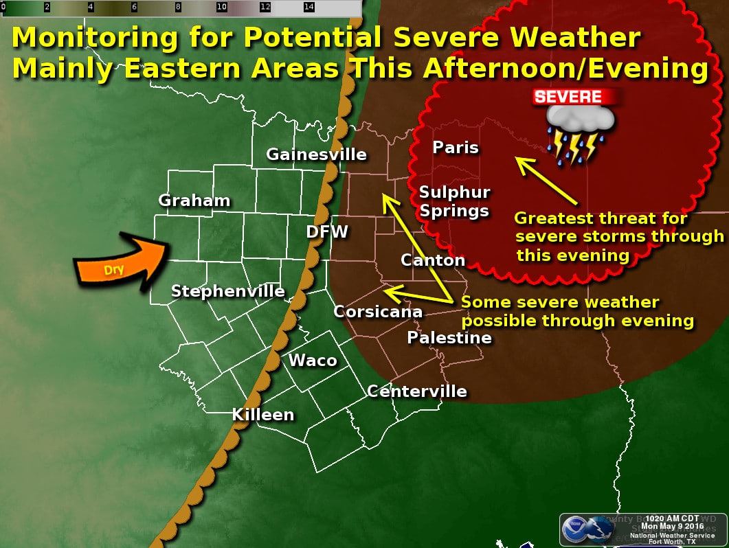
- Isolated thunderstorm development is possible after 3 PM to the east of the dryline. The dryline is expected to be located near I-35/I-35W by this time.
- Thunderstorm coverage this afternoon and evening will not be high; perhaps only a couple of storms.
- Those storms that do develop will quickly intensify and will likely become severe. The threat of large hail and damaging wind gusts will be the primary issue initially.
- The threat for a couple tornadoes will be highest in Northeast Texas late this afternoon and evening as storms move into a more favorable enviornment.
- A stronger cap and weaker lift will result in thunderstorms becoming less likely with southward extent. The most likely regions to be impacted by a few supercells today will be eastern sections of North Texas and Northeast Texas.
- The first storms may develop within the D/FW Metroplex after 3 PM. While they may strengthen quickly the highest severe weather risk should be east/northeast of D/FW.
- If the dryline is slower in eastward progression the severe weather risk may shift west by 15-30 miles. While not normally a big deal that would mean a higher chance for some severe weather in D/FW this afternoon. Trust me – you’ll be able to see any storms that get going. Keep an eye to the sky.
- Thunderstorms should be out of the D/FW Metroplex by 5-6 PM and into Northeast Texas. The 5 PM to 9 PM timeframe will be when we may have a few tornadoes in Northeast Texas. We may get away with the strongest storms staying on the north side of the Red River – but I’m certainly not going to call that now.


0 Comments