
This is going to be a very interesting weekend across Texas. Confidence of a crippling winter storm continues to increase, but that doesn’t mean everyone is going to receive the same impacts. Severe thunderstorms and flooding are also going to be hazards this weekend. Luckily Christmas Eve and most of Christmas Day will be quiet; however, shower and thunderstorm chances will be on the increase Christmas night across North Texas. By Saturday morning, there could be a few strong to severe thunderstorms across North Texas, then the risk of severe weather and flash flooding increases on Saturday afternoon and early Sunday across North Texas, Central Texas, South Texas, Southeast Texas, East Texas, and Northeast Texas.
Severe Weather and Flooding:
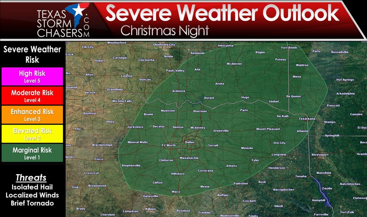
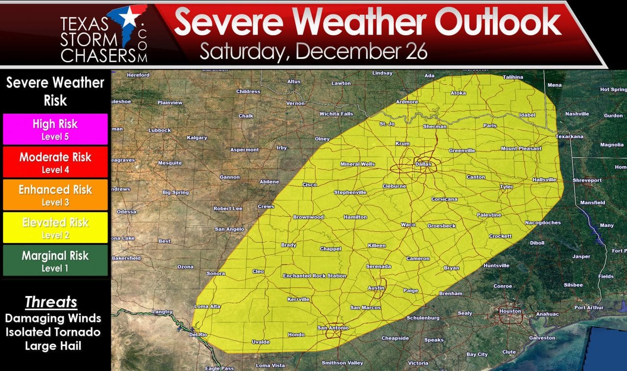
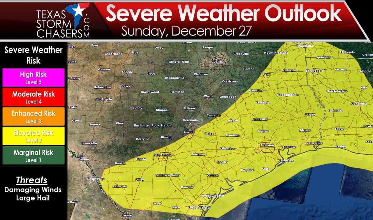
Here are the severe weather outlooks for Christmas night, Saturday, and Sunday. At this time I don’t anticipate any widespread severe weather outbreaks or high-end severe weather Saturday or Sunday, but we will have to keep an eye on trends since we will be dealing with a very powerful storm system.
Along with a severe weather threat, we anticipate a significant flooding threat on the warm-side of this storm system. Current rain forecasts have the heaviest rain accumulations across Northeast Texas, North Texas, and East Texas. Widespread rain totals of 2 to 4 inches are likely. Some folks could receive 5 to 7 inches of rain. Vegetation is dormant, soils are saturated, and rivers are running high. All indications are this could be another round of significant flooding across the region. Flash flooding will be possible since soils won’t be able to absorb much rain. Once flash flooding issues die down we’ll have to deal with another round of significant river and lake rises. Jenny talked about the severe weather and flooding threats in detail earlier today. You can read that blog here. The purpose of this article is to discuss the cold side of this storm system. Yup – it’s going to snow…in fact, some folks are going to get buried in snow.
Winter Weather:
Forecasting winter weather in Texas is difficult enough a day out, so keep in mind we’re talking about an event three to four days down the road. Normally I wouldn’t get too detailed, but this is a unique event. Confidence continues to increase this will be a high-end winter storm and blizzard for the panhandle and parts of the south plains. It’s going to happen right after Christmas and during a busy travel period.
Let me start out by sharing the ‘winter weather’ hazard map. I put this map together based off information from local National Weather Service offices and a blend of weather models. This graphic shows a general overview of potential winter weather conditions beginning Saturday Night and lasting through Monday. The winter weather threat would begin first in the Texas Panhandle and far western parts of the state Saturday Night. As temperatures fall below freezing further south on Sunday, the threat for winter weather will shift south to include the Permian Basin, West Texas, and perhaps across portions of Northwest Texas, the Big Country, and the Concho Valley. As area of low pressure moves east into North Texas on Monday we could see rain change over to light snow in western North Texas. The graphic I’ve included does not include any potential sleet/ice zone or the chance for lighter snow on the eastern edge of the risk area. I guarantee the setup on this graphic will change several times as new model data arrives. With the disclaimers out of the way, let’s get to it!
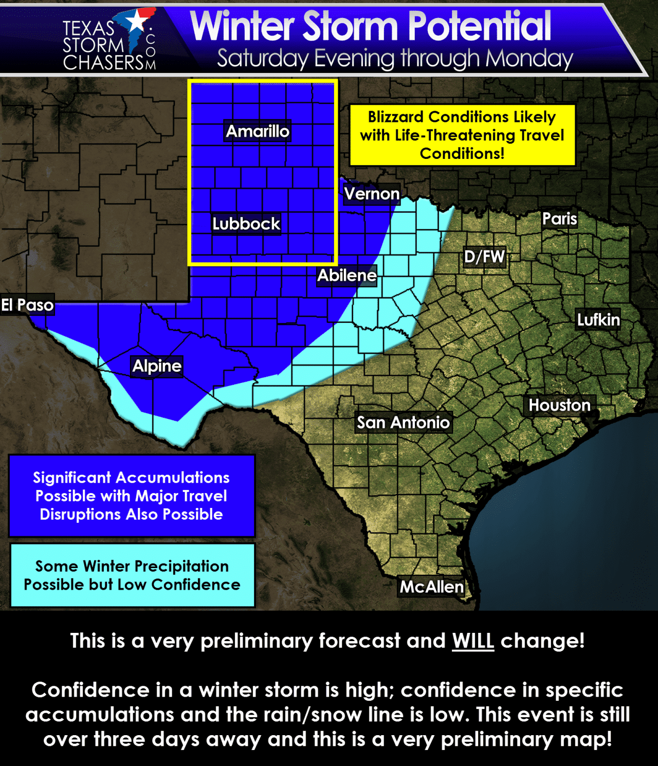
Confidence is high regarding the winter storm threat for the Texas Panhandle, South Plains, Rolling Plains, and Permian Basin. I won’t try to get into snow amounts this far out but there is the potential for significant snow accumulations over 6 inches. If the more aggressive weather model guidance verifies some locations will receive over a foot of snow – that is something we’ll narrow down as we get closer to the weekend. Winter precipitation is most likely to form on the north/northwest sides of the low pressure system that will track across Texas. If the low takes a more northerly path then the winter weather lines will have to be pushed further north. If the low tracks further south than we’ll have to bring the snow lines further south and east. The low will be intensifying (deepening) as it moves across Texas. The result will be a tight pressure gradient and strong wind gusts. Some gusts could exceed 50 MPH and blizzard conditions are likely in portions of the dark-blue shading on our hazard map above. Travel will likely become impossible on Sunday and Monday across the Texas Panhandle, West Texas, and perhaps as far south as the Permian Basin due to blizzard conditions. I wouldn’t be surprised if roads were closed due to the dangerous conditions anticipated. This looks to be the most significant winter storm we’ve seen in a couple of years.
With significant snow accumulations and high winds likely, I’m also concerned about the potential for power outages across the Texas Panhandle and West Texas this weekend into early next week. Wind chill values will likely drop below zero resulting in dangerously cold temperatures. The light-blue shading is where confidence in winter weather is lower – but certainly possible. If the low tracks further south/east or the colder air advances more quickly than we’ll have to introduce winter weather/snow chances further east into North Texas and the Hill Country.
I realize I’m being purposely vague but you must realize that a small track change in the low will result in significant forecast adjustments. This is not our first rodeo with significant winter storms across the state, and we all know that significant forecast changes can happen between now and the actual event. I do believe we will have a very significant winter storm in Texas on Sunday and Monday. I do expect roads to be closed in the hardest hit areas. Some locations will likely see 6-12 inches of snow – perhaps more in spots. Strong north winds may gust over 50 MPH resulting in whiteout conditions and result in a true blizzard. Don’t even bother trying to travel across the Texas Panhandle, West Texas, Permian Basin, or west of Interstate 35 in Oklahoma beginning Saturday night and through Monday. If you have travel plans for those areas in that timeframe you need to change them – its that simple.


0 Comments