A major storm system will bring a variety of weather hazards to Texas beginning Thursday and tapering off by Saturday. The impacts could last into next week. A Winter Storm Watch is now in effect for the Texas Panhandle beginning Thursday Night and ending on Saturday. Temperatures are expected to fall below freezing late Thursday or early Friday. Once temperatures fall below freezing we anticipate a changeover from rain to freezing rain. A bit of snow may mix in across the northwest Texas Panhandle. By far the primary precipitation mode should be freezing rain. Based on anticipated moisture levels and current forecasts some locations may pick up between a quarter to half inch of ice accumulation. Remember that it only takes a glaze to turn roads into skating rinks. Once you start talking about ice accumulations above half an inch you have to start talking about localized power outages and tree damage. For a winter weather event we’re still pretty far away and we do anticipate forecast changes as we get closer. Hazardous travel conditions are likely across the Texas Panhandle, Western Oklahoma, and adjacent portions of Kansas on Friday into Saturday.
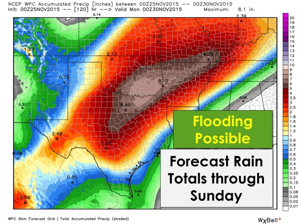
Farther east where temperatures will remain above freezing we’ll be dealing with liquid rain and a whole lot of it. Rain accumulation forecasts continue to increase with the highest rain totals located over the Big Country, North Texas, and Northeast Texas. Widespread 5 to 7 inch rain totals are expected with isolated amounts up to 10 inches. Soils remain saturated from previous precipitation events and the recent hard freeze has caused most vegetation to become dormant for the winter. Flash flooding and river flooding all look like threats we’re going to deal with beginning late Thursday into Friday. The rains will move out on Saturday but we’ll be dealing with flood problems well into next week. Lower rain totals are expected across the Concho Valley, South-Central Texas, the Brazos Valley, and East Texas with 2 to 4 inches of rain possible. Localized flooding will still be a threat even in those areas. Overall I do expect a busy period of weather beginning on Thursday (maybe later in the day) with the peak on Friday and the first half of Saturday. Temperatures will be above freezing – but its still going to be cold. Wind chill values will be in the 20s with temperatures in the mid to upper 30s. If we by chance get folks caught out in flooding hypothermia could be a real threat.


0 Comments