
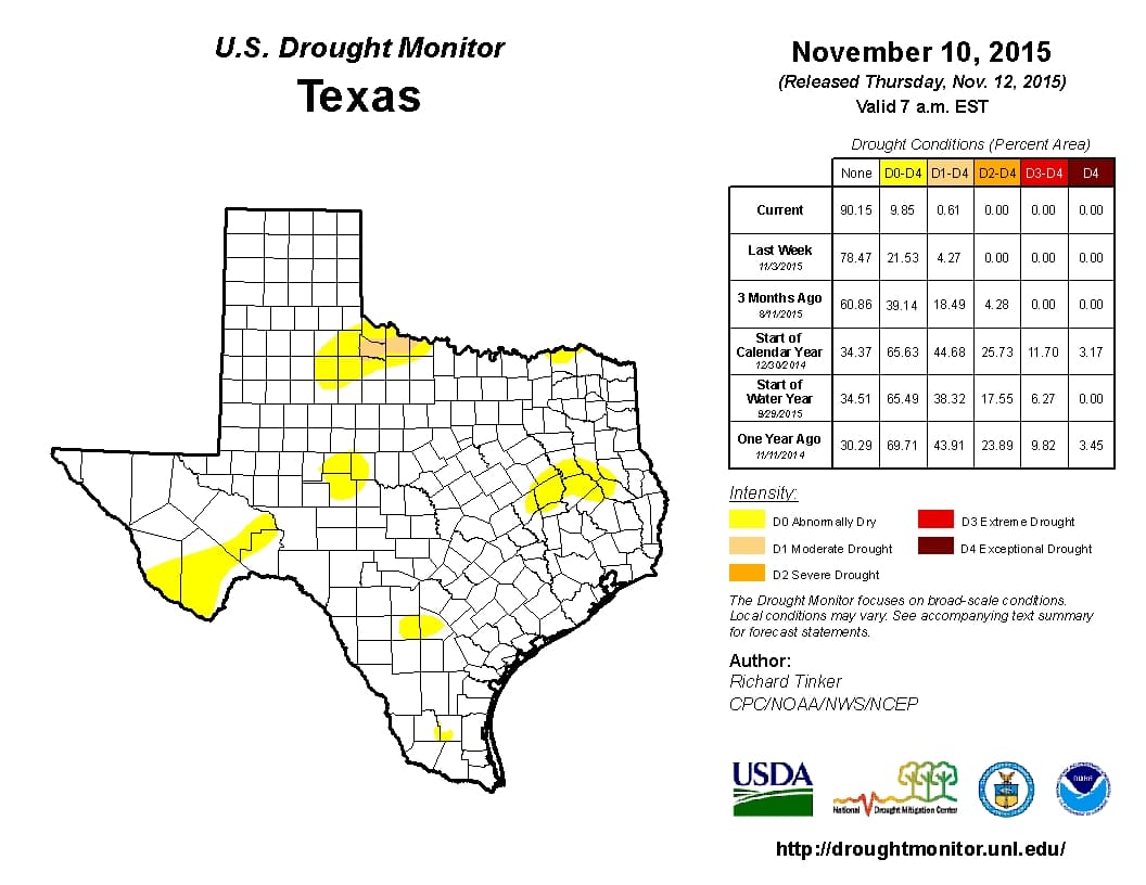
What a year this has been for the drought in Texas. It was obliterated back in May and June but rapidly returned for the summer months. We were getting slammed by questions about El Nino and why it hadn’t shown up. I believe the past few weeks have clearly shown that El Nino is present. With the rains over the past couple of weeks the drought has once again been all but obliterated from Texas. The brand new drought monitor has 99.39 percent of Texas out of an official drought designation! An intense storm system is expected to bring a widespread precipitation event to Texas early next week so we’re not done yet!
The following statement accompanied the updated drought monitor from the National Drought Mitigation Center.
The Southeastern Great Plains, Lower Mississippi Valley, and Adjacent Southeast
Moderate to heavy precipitation fell on most of this region. Most areas from the Mississippi/Ohio Confluence southward through the Lower Mississippi Valley, southeastern Oklahoma, and eastern Texas reported at least an inch of precipitation, with 2 to locally over 5 inches measured in a swath from southern Missouri into northwestern Arkansas, plus an area farther south extending from southeast Oklahoma and northeastern Texas eastward through southern Arkansas, much of Louisiana, and some parts of Mississippi outside the areas of abnormal dryness and moderate drought. Large areas of improvement were introduced in the wetter areas, and most other areas were unchanged; however, D0 was expanded into parts of eastern Arkansas, southwestern Tennessee, and northwestern Mississippi that missed most of the precipitation. The eastern half of this area received only 50% to 75% of normal rainfall in the last 30 days, and deficits of 4 to locally 6 inches have accumulated since early September.
Looking Ahead
During November 12-16, the heaviest precipitation should fall on windward slopes in western Washington and northern Idaho. Peak values of 12 to nearly 18 inches are anticipated in the northwesternmost reaches of Washington while totals may top 6 inches in northernmost Idaho. Substantial totals are also expected in western Oregon and far northwestern California, with amounts topping out in the 2 to 4 inch range along the Oregon Coast. Relatively heavy precipitation is also anticipated across the northern half of the Great Lakes, with 2 to 3 inches forecast in northwestern Wisconsin and adjacent areas. Meanwhile, moderate precipitation (with amounts above 2 inches only in a few isolated locations) is expected across the northern half of New England and New York, far southern Florida, the southeastern Great Plains and western Lower Mississippi Valley, and parts of the northern Sierra Nevada and southern Cascades. Temperatures should average well above normal (5 to 10 degrees) in the northern half of the Plains and much of the Great Lakes Region. In contrast, temperatures should average around 3 degrees below normal in the Great Basin and central Intermountain West.
For the ensuing 5 days (November 17-21), the odds at least slightly favor wetter than normal conditions nationwide, except in a small part of the northern Plains and in a swath across the Big Bend of Texas, southern sections of Arizona and New Mexico, and central and southern California. All of Alaska has enhanced chances for above normal precipitation as well. The best chances for wetness are in the southern half of the Mississippi Valley. We should see warmer than normal temperatures on average in the central and eastern parts of the country and cooler than typical conditions from the Rockies westward.


0 Comments