
A Tornado WATCH has been issued for portions of southeast, south central including coastal Texas this afternoon through midnight tonight. A few strong to severe thunderstorms capable of producing tornadoes will be likely across the area this afternoon and evening as the remnants of Tropical Storm Bill move inland. Waterspouts along the coast within the Watch area will also be possible…with one already reported recently in the Galveston area. These are also likely to pop up with little to no warning which means it’s critical that you take immediate action should a warning be issued for your location.
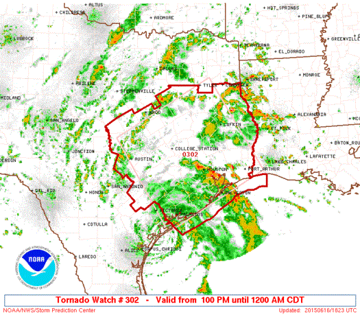
TORNADO WATCH NUMBER 302
   NWS STORM PREDICTION CENTER NORMAN OK
   100 PM CDT TUE JUN 16 2015

   THE NWS STORM PREDICTION CENTER HAS ISSUED A

   * TORNADO WATCH FOR PORTIONS OF
     SOUTHEASTERN AND EAST CENTRAL TEXAS
     COASTAL WATERS

   * EFFECTIVE THIS TUESDAY AFTERNOON FROM 100 PM UNTIL MIDNIGHT
     CDT.

   * PRIMARY THREATS INCLUDE...
     A FEW TORNADOES POSSIBLE
     ISOLATED DAMAGING WIND GUSTS TO 70 MPH POSSIBLE

   SUMMARY...SHOWERS AND THUNDERSTORMS...SOME OF WHICH MAY BECOME
   CAPABLE OF TORNADOES...EXPECTED TO INCREASE NEAR AND EAST OF TRACK
   OF TROPICAL STORM BILL THROUGH LATE TONIGHT AS THAT SYSTEM TRACKS
   GENERALLY NORTH-NORTHWESTWARD.

   THE TORNADO WATCH AREA IS APPROXIMATELY ALONG AND 105 STATUTE
   MILES EITHER SIDE OF A LINE FROM 55 MILES SOUTH SOUTHEAST OF
   AUSTIN TEXAS TO 30 MILES EAST OF LUFKIN TEXAS.


0 Comments