
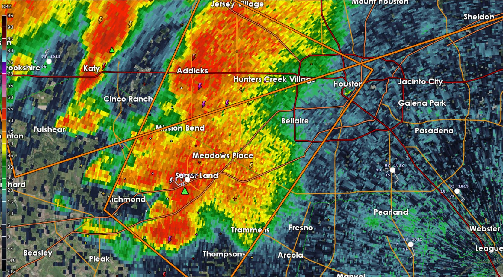
Severe Thunderstorm Warning for Fort Bend and Harris Counties in Southeast Texas until 9:15 PM. A supercell thunderstorm located over south Sugar Land is moving northeast at 35 MPH. Meanwhile a line of severe thunderstorms is northwest of the Houston Metro moving southeast. This supercell is what we’re watching because its showing signs of rotation which may be enhanced as the squall line continues to approach. Be ready to act in the event a tornado warning is issued. Sugarland, Meadows Place, Bellaire, and Mission Bend are in the path of this storm.
SEVERE THUNDERSTORM WARNING
NATIONAL WEATHER SERVICE HOUSTON/GALVESTON TX
845 PM CDT MON MAY 25 2015
THE NATIONAL WEATHER SERVICE IN LEAGUE CITY HAS ISSUED A
* SEVERE THUNDERSTORM WARNING FOR…
CENTRAL HARRIS COUNTY IN SOUTHEASTERN TEXAS…
NORTHEASTERN FORT BEND COUNTY IN SOUTHEASTERN TEXAS…
* UNTIL 915 PM CDT
* AT 845 PM CDT…DOPPLER RADAR INDICATED A SEVERE THUNDERSTORM
CAPABLE OF PRODUCING HALF DOLLAR SIZE HAIL AND DAMAGING WINDS IN
EXCESS OF 60 MPH. THIS STORM WAS LOCATED OVER SOUTHERN SUGAR
LAND…AND MOVING NORTHEAST AT 35 MPH.
* LOCATIONS IMPACTED INCLUDE…
SUGAR LAND…MISSOURI CITY…NORTHEASTERN ROSENBERG…STAFFORD…
BELLAIRE…WEST UNIVERSITY PLACE…RICHMOND…JERSEY VILLAGE…
HUNTERS CREEK VILLAGE…BUNKER HILL VILLAGE…PINEY POINT
VILLAGE…SPRING VALLEY…GREATER FIFTH WARD…FOURTH WARD…TOWN
WEST…PECAN GROVE…FIRST COLONY…SPRING BRANCH WEST…NEARTOWN /
MONTROSE AND DOWNTOWN HOUSTON.
PRECAUTIONARY/PREPAREDNESS ACTIONS…
A TORNADO WATCH REMAINS IN EFFECT FOR THE AREA. ALTHOUGH A TORNADO IS
NOT IMMEDIATELY LIKELY…IF ONE IS SPOTTED…ACT QUICKLY AND MOVE TO
A PLACE OF SAFETY IN A STURDY STRUCTURE…SUCH AS A BASEMENT OR SMALL
INTERIOR ROOM.
TORRENTIAL RAINFALL IS ALSO OCCURRING WITH THIS STORM…AND MAY LEAD
TO FLASH FLOODING. DO NOT DRIVE YOUR VEHICLE THROUGH FLOODED
ROADWAYS.


0 Comments