
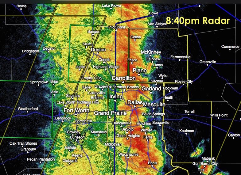
Severe Thunderstorm Warnings have been issued for Rockwall and Kaufman counties until 9:30pm. The approaching storms have a history of quarter size hail and damaging winds in excess of 60mph. The line appears to be picking up some speed and moving east now at about 40mph. Localized flash flooding from brief heavy rain could also be a concern. Best to just stay put until the storm passes before venturing out and about tonight!
Advertisements
SEVERE THUNDERSTORM WARNING
NATIONAL WEATHER SERVICE FORT WORTH TX
837 PM CDT SAT APR 18 2015

THE NATIONAL WEATHER SERVICE IN FORT WORTH HAS ISSUED A

* SEVERE THUNDERSTORM WARNING FOR...
  KAUFMAN COUNTY IN NORTH CENTRAL TEXAS...
  ROCKWALL COUNTY IN NORTH CENTRAL TEXAS...

* UNTIL 930 PM CDT

* AT 835 PM CDT...SEVERE THUNDERSTORMS WERE LOCATED ALONG A LINE
  EXTENDING FROM NEAR GARLAND TO NEAR COMBINE TO CORSICANA...MOVING
  EAST AT 40 MPH.

  HAZARD...60 MPH WIND GUSTS.

  SOURCE...RADAR INDICATED.

  IMPACT...EXPECT DAMAGE TO ROOFS...SIDING AND TREES.

* SEVERE THUNDERSTORMS WILL BE NEAR...
  ROCKWALL...HEATH AND COTTONWOOD AROUND 850 PM CDT.
  ROYSE CITY AROUND 900 PM CDT.
  KEMP AROUND 905 PM CDT.
  MABANK AROUND 910 PM CDT.


0 Comments