
A cold front and upper level disturbance will combine forces tomorrow afternoon/evening across northern Texas bringing our first enhanced threat for severe storms this year. The Storm Prediction Center has placed portions of northwest and north central Texas…mainly the areas just west/northwest of Ft. Worth…under Risks for seeing severe thunderstorm development tomorrow afternoon and evening. We have to stress that a majority of tomorrow afternoon’s severe storm activity is anticipated to be confined to southwestern Oklahoma along the leading edge of an approaching cold front. However, there is the chance for a few discrete storms to fire up west and northwest of the Dallas/Ft. Worth metroplex…mainly north of I-20 between Wichita Falls and Abilene. If these storms develop, they will have the capability of producing very large hail greater than 2 inches in diameter, damaging winds in excess of 60mph and an isolated tornado threat. Best guess right now at timing for storm initiation would be anytime after 4pm tomorrow afternoon across southwestern Oklahoma and western north Texas. As we get later into the evening hours, it’s expected that the cold front will undercut most of the storms which will limit the tornado potential considerably. There will still be a threat for hail, wind damage and dangerous lightning as the storms become linear while approaching the DFW metroplex. Those with outdoor activities planned tomorrow afternoon and evening will need to keep an eye on the sky and seek shelter should threatening weather approach your location. For residents outside of the Enhanced and Slight Risk areas, any storms that form down the line will be less severe and bring mainly gusty winds, brief heavy downpours and some lightning. As the line of storms moves quickly southeast along with the cold front overnight, rainfall amounts are expected to be under 1/4 to 1/2 of an inch.
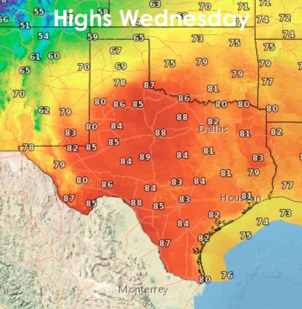
 Lows tonight will be mild and in the 50’s and 60’s east of the dryline (a north/south airmass boundary dividing more humid air to the east from drier air to the west) which will be retreating west as we head into the nighttime hours. Drier air out west will allow temps to cool down into the 40s and low 50s overnight tonight. Highs tomorrow will be quite warm ahead of the cold front with temps in the 80s expected across much of the state. For far western Texas and the northern panhandle, your highs tomorrow will be cooler and in the 60s and low 70s. After this, we stay cooler and drier for the rest of the work week and into the weekend. By Sunday, we’ll be warming back up into the 80s…and the best part…we get a break from the rain for just a little while until our next upper level system rolls in early next week!


0 Comments