
A Winter Weather Advisory will be in effect for snow and freezing drizzle between 6am Friday morning through 6pm Saturday. This includes Dallas, Ft. Worth, Bonham, Paris, Sherman/Dennison, Greenville, McKinney, Denton, Decatur, Graham, Breckenridge, Mineral Wells, Weatherford, Stephenville and Cleburne. Snow is anticipated to fall within the advisory area tomorrow with accumulations between 2 to 4 inches possible mainly across the western and northern portions of the advisory area. Some areas could get some thunder with enhanced snowfall as a result of convective banding. The track of the upper level disturbance bringing us this weather will have an impact on both snow locations and totals, so adjustments to the Advisory area may be necessary tomorrow. We’re all very familiar with that from Wednesday’s setup. This snow, unlike what fell on Wednesday, will be lighter and not as wet and heavy due to the colder air aloft and at the surface. As this snow will be falling primarily during the daytime…after everyone is at work and/or school…it could mean some slick roads for the commute home in the afternoon. Plan accordingly!
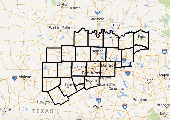
URGENT - WINTER WEATHER MESSAGE
NATIONAL WEATHER SERVICE FORT WORTH TX
325 PM CST THU FEB 26 2015

TXZ091-092-100>102-115-116-129-270530-
/O.NEW.KFWD.WW.Y.0005.150227T1200Z-150301T0000Z/
MONTAGUE-COOKE-YOUNG-JACK-WISE-STEPHENS-PALO PINTO-EASTLAND-
INCLUDING THE CITIES OF...BOWIE...NOCONA...GAINESVILLE...GRAHAM...
OLNEY...JACKSBORO...DECATUR...BRIDGEPORT...BRECKENRIDGE...
MINERAL WELLS...CISCO...EASTLAND...RANGER...GORMAN
325 PM CST THU FEB 26 2015

...WINTER WEATHER ADVISORY IN EFFECT FROM 6 AM FRIDAY TO 6 PM CST
SATURDAY...

THE NATIONAL WEATHER SERVICE IN FORT WORTH HAS ISSUED A WINTER
WEATHER ADVISORY FOR SNOW AND FREEZING RAIN...WHICH IS IN EFFECT
FROM 6 AM FRIDAY TO 6 PM CST SATURDAY.

* LOCATION...THIS STATEMENT IS FOR AREAS ALONG AND NORTHWEST OF A
  LINE FROM EASTLAND TO MINERAL WELLS TO GAINESVILLE.

* TIMING...FRIDAY MORNING THROUGH SATURDAY AFTERNOON.

* PRECIPITATION TYPE...SNOW IS LIKELY FRIDAY. LIGHT SNOW OR
  FREEZING DRIZZLE IS LIKELY FRIDAY NIGHT AND SATURDAY.

* ACCUMULATION...2 TO 4 INCHES OF SNOW FRIDAY. A TENTH OF AN INCH
  OR LESS OF ICE FROM FREEZING DRIZZLE SATURDAY.

* MAIN IMPACT...SNOW AND ICE WILL MAKE FOR HAZARDOUS TRAVEL.
  TEMPERATURES WILL BE COLD ENOUGH FOR ACCUMULATIONS ON ALL
  ROADS...BRIDGES...AND OVERPASSES.

PRECAUTIONARY/PREPAREDNESS ACTIONS...

A WINTER WEATHER ADVISORY MEANS THAT PERIODS OF WINTER
PRECIPITATION MAY CAUSE TRAVEL DIFFICULTIES. BE PREPARED FOR
SLIPPERY ROADS AND PLAN ON SOME TRAVEL DELAYS.


0 Comments