
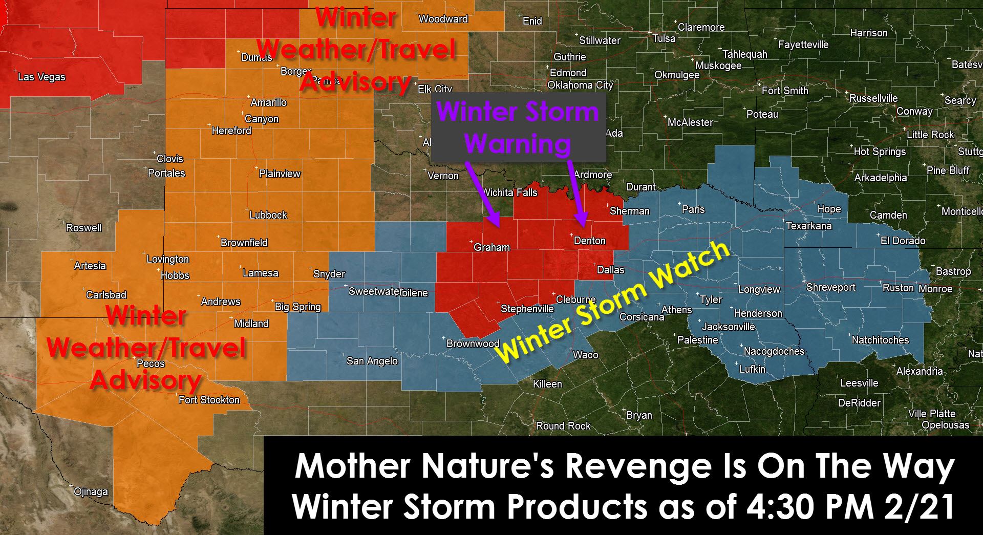
We all knew this day would eventually come. After a relatively calm and mild winter Mother Nature is getting her revenge. This upcoming week will feature the coldest air mass we’ve seen this winter and at least two storm systems will bring winter weather to Texas. In addition to the winter storm arriving this weekend indications are another winter storm could bring a trio of high-impact weather to Texas beginning Thursday and continuing into Saturday. We’re going to focus on one thing at a time. As usual we’ll start out this update with a summary of the current watches/advisories/warnings. A Winter Storm Watch means significant winter precipitation may produce accumulations resulting in potential impacts to travel in the coming 2 days. A winter weather/travel advisory means winter weather is expected that may result in slick road conditions and accumulations. A winter storm warning is the highest alert level and means significant accumulations are expected with dangerous travel conditions and a relatively high-impact winter weather event.
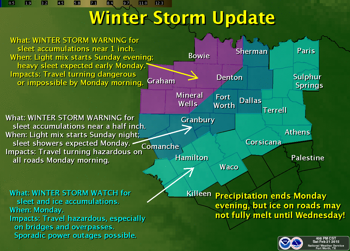
A Winter Storm Warning is in effect Sunday Night through Monday Night for portions of North Texas. A few cities included are Comanche, Stephenville, Eastland, Graham, Jacksboro, Bowie, Gainesville, Sherman, McKinney, Denton, Fort Worth, Arlington, Dallas, Cleburne, Weatherford, and Decatur. Sleet accumulations up to 0.5 to 1.5 inches on all surfaces, including roadways, is possible. This storm has the potential to produce significant impacts to the Monday rush hour(s) in the D/FW Metroplex.
A Winter Storm Warning is in effect for the Northwest Texas Panhandle this evening through Monday morning. A few towns included are Dalhart, Stratford, Spearman, Gruver, Hartley, and CHanning. Snow accumulations of 5 to 9 inches are possible as moderate to heavy snow spreads across the area late tonight into Sunday and early Monday. With temperatures in the teens and twenties roads will quickly become snow packed and slick. Wind chill values will fall into the single digits.
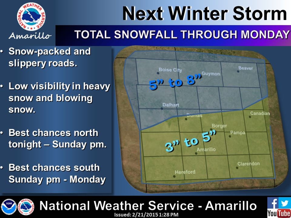
A Winter Weather Advisory/Travel Advisory is in effect for the Texas Panhandle this evening through Monday morning. A few cities included are Perryton, Canadian, Pampa, Wheeler, Shamrock, Wellington, Clarendon, Amarillo, Canyon, and Hereford. Snow is expected to begin late tonight/early Sunday. Snow accumulations of 1 to 6 inches can be expected with the lighter totals in the southeast Panhandle getting heavier as you move north/northwest. Snowpacked and slick roads are a good bet on Sunday into early Monday.
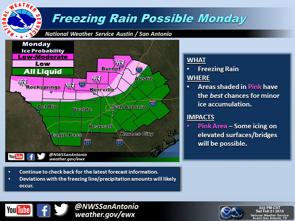
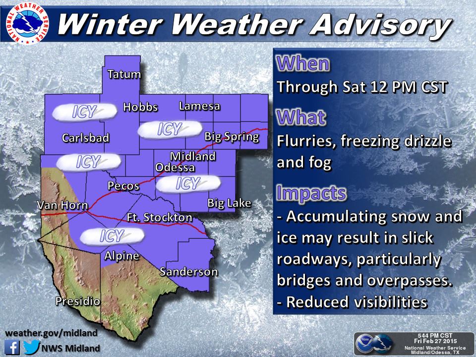
A Winter Weather Advisory/Travel Advisory is in effect for West Texas (South Plains, Rolling Plains) and the Permian Basin Sunday evening through Monday morning. A few cities included are Childress, Plainview, Lubbock, Floydada, Paducah, Post, Littlefield, Brownfield, Lamesa, Seminole, Snyder, Big Spring, Midland, Odessa, Pecos, Van Horn, Fort Stockton, Alpine, and Big Lake. A mix of sleet/snow across the South Plains and sleet/freezing rain across the Permian Basin will create slick travel conditions later on Sunday into Monday morning.
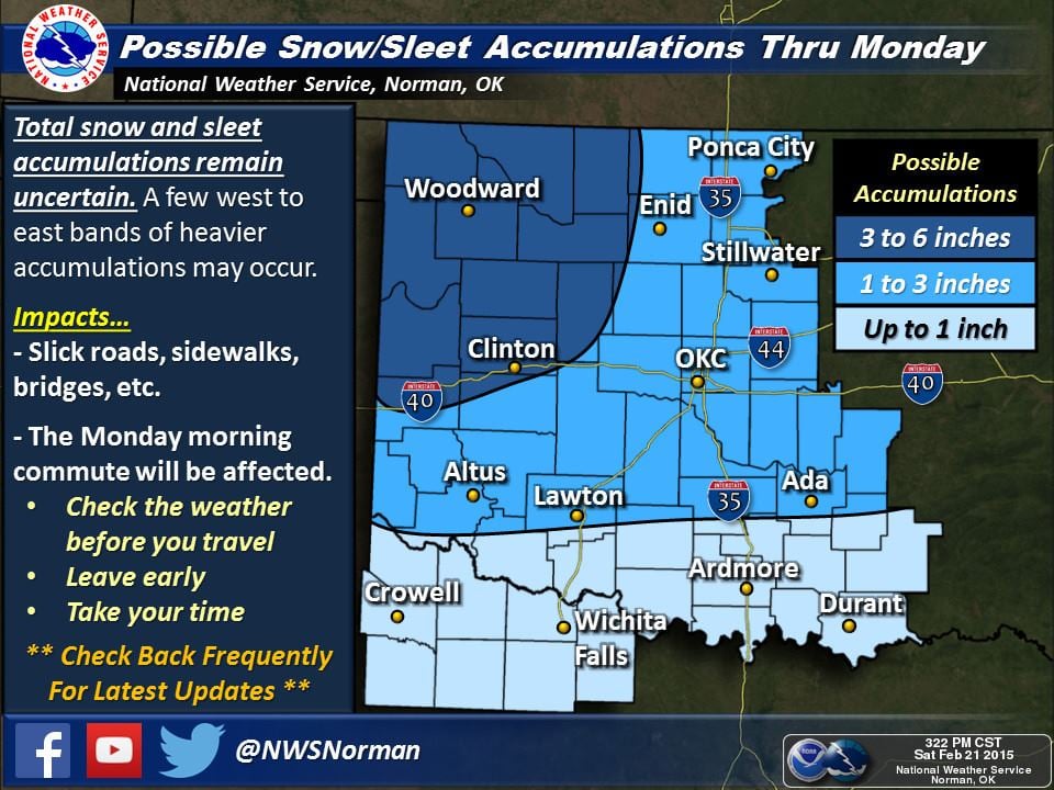
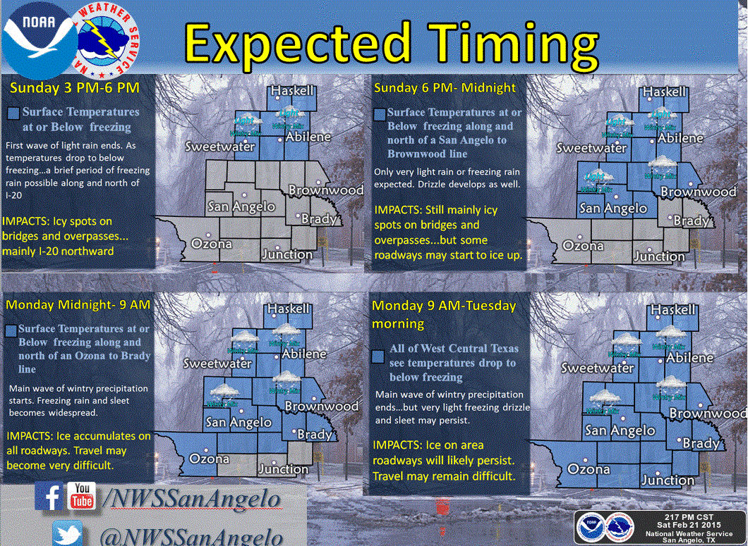
A Winter Storm Watch is in effect Sunday evening through Monday evening for the Concho Valley, West-Central Texas, portions of North-Central Texas, Northeast Texas, and parts of East Texas. A few cities included are Texarkana, Longview, Tyler, Nacogdoches, Lufkin, Paris, Sulphur Springs, Greenville, Waxahachie, Corsicana, Waco, Hamilton, Brownwood, Abilene, Sweetwater, San Angelo, and Sterling City. A mix of sleet/freezing rain across the Concho Valley, West-Central Texas, and North-Central Texas could create slick and hazardous roads Sunday night into Monday. These areas will likely be upgraded to a Winter Storm Warning/Winter Weather Advisory later tonight. A mix of sleet/freezing rain is possible in East and Northeast Texas late Sunday Night into Monday with slick road conditions also possible. We should see this area upgraded to a winter weather advisory late tonight or early Sunday.
Honestly it took me a lot longer than I thought it would to compile all those warnings/advisories/watches. I also find it interesting that Interstate 20 from the Texas/Louisiana line west to Van Horn (over 500 miles) is expecting winter weather on Sunday/Monday. That goes to show how widespread and large this winter storm will become. Texas is a great state and I love it, but man sometimes I wish it was a little smaller so I could focus more on one specific area during these large-scale events. I won’t bore you with any additional text so here are local accumulation and winter weather forecasts for your part of Texas from National Weather Service offices. If you’re not mentioned here it means you probably won’t see winter weather.


0 Comments